Mantova geodata
Mantova (Lombardy) is a seat of a second-order administrative division; located in Italy in Europe/Rome (GMT+2) time zone. With population of 39,260 people, there are 183 cities with bigger population in this country. Compared to other cities in Italy, 64.1% of cities are located further ↓South; 59.7% of cities are located further →East and 85.6% of cities have higher elevation than Mantova. Note1


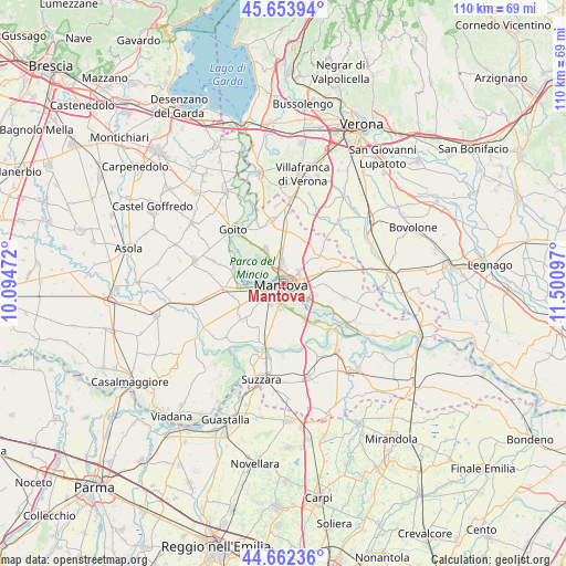
Mantova GPS coordinates[2]
45° 9' 37.116" North, 10° 47' 52.224" East
| Map corner | latitude | longitude |
|---|---|---|
| Upper-left | 45.65394°, | 10.09472° |
| Center: | 45.16031°, | 10.79784° |
| Lower-right: | 44.66236°, | 11.50097° |
| Map W x H: | 110.3×110.3 km | = 68.5×68.5mi |
| max Lat: | 47.04031° ⇑35.9% North |
| Mantova: | 45.16031° |
| min Lat: | ⇓64.1% South 35.50142° |
| min Long | Mantova | max Long |
| 6.69888° | 10.79784° | 18.48682° |
| W 40.3%⇐ | ⇒59.7% E |
Elevation
Elevation of Mantova is 29 m = 95 ft, and this is 277.7 m = 911 ft below average elevation for this country.
| Max E: |
2085 m = 6841 ft | 85.6% |
| Avg. | 306.7 m = 1006 ft | |
| Mantova | 29 m = 95 ft | |
Min E: |
-4 m = -13 ft | 14.4% |
See also: Italy elevation on elevation.city.
Geographical zone
Mantova is located in North temperate zone (between Tropic of Cancer and the Arctic Circle). Distance of this North polar circle is 2379.8 km =1478.7 mi to North.| Distance of | km | miles | from Mantova |
|---|---|---|---|
| North Pole | 4985.7 | 3098 | to North |
| Arctic Circle | 2379.8 | 1478.7 | to North |
| Tropic Cancer | 2415.4 | 1500.9 | to South |
| Equator | 5021.4 | 3120.2 | to South |


Nearby cities:
15 places around Mantova: (largest is in red/bold)
• Cappelletta
6.3 km =3.9 mi,  193°
193°
• Cerese
4.7 km =2.9 mi, 188°
• Eremo
5.4 km =3.4 mi,  233°
233°
• Formigosa
6.6 km =4.1 mi,  126°
126°
• Gazzo
8.1 km =5 mi,  74°
74°
• Levata
4.6 km =2.9 mi,  210°
210°
• Lunetta-Frassino
1.8 km =1.1 mi,  90°
90°
• Marmirolo
7.3 km =4.5 mi,  333°
333°
• Montanara
6.8 km =4.2 mi,  245°
245°
• Mottella
3.7 km =2.3 mi,  83°
83°
• Pietole
5.4 km =3.4 mi,  162°
162°
• San Biagio
7.8 km =4.8 mi,  150°
150°
• Sant'Antonio
4 km =2.5 mi,  355°
355°
• Soave
7 km =4.3 mi,  303°
303°
• Stradella
6.1 km =3.8 mi, 77°
In other languages:
- In Spanish: Provincia de Mantua
- In France: Province de Mantoue
- In German: Provinz Mantua
- In Russian: Мантуя
- In Chinese: 曼托瓦省
Sources, notices
• [Note1] Compared only with cities in Italy existing in our database
• [Src1] Map data: © OpenStreetMap contributors (CC-BY-SA)
• [Src2] Other city data from geonames.org with taken over terms of usage.
• [Src3] Geographical zone / Annual Mean Temperature by Robert A. Rohde @ Wikipedia
