Eremo geodata
Eremo (Lombardy) is a populated place; located in Italy in Europe/Rome (GMT+2) time zone. With population of 5,232 people, there are 1868 cities with bigger population in this country. Compared to other cities in Italy, 63.2% of cities are located further ↓South; 60.5% of cities are located further →East and 87.4% of cities have higher elevation than Eremo. Note1


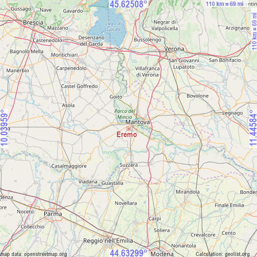
Eremo GPS coordinates[2]
45° 7' 52.284" North, 10° 44' 33.756" East
| Map corner | latitude | longitude |
|---|---|---|
| Upper-left | 45.62508°, | 10.03959° |
| Center: | 45.13119°, | 10.74271° |
| Lower-right: | 44.63299°, | 11.44584° |
| Map W x H: | 110.3×110.3 km | = 68.5×68.5mi |
| max Lat: | 47.04031° ⇑36.8% North |
| Eremo: | 45.13119° |
| min Lat: | ⇓63.2% South 35.50142° |
| min Long | Eremo | max Long |
| 6.69888° | 10.74271° | 18.48682° |
| W 39.5%⇐ | ⇒60.5% E |
Elevation
Elevation of Eremo is 24 m = 79 ft, and this is 282.7 m = 927 ft below average elevation for this country.
| Max E: |
2085 m = 6841 ft | 87.4% |
| Avg. | 306.7 m = 1006 ft | |
| Eremo | 24 m = 79 ft | |
Min E: |
-4 m = -13 ft | 12.6% |
See also: Italy elevation on elevation.city.
Geographical zone
Eremo is located in North temperate zone (between Tropic of Cancer and the Arctic Circle). Distance of this North polar circle is 2383.1 km =1480.8 mi to North.| Distance of | km | miles | from Eremo |
|---|---|---|---|
| North Pole | 4988.9 | 3100 | to North |
| Arctic Circle | 2383.1 | 1480.8 | to North |
| Tropic Cancer | 2412.2 | 1498.9 | to South |
| Equator | 5018.1 | 3118.1 | to South |


Nearby cities:
15 places around Eremo: (largest is in red/bold)
• Buscoldo
5.5 km =3.4 mi,  221°
221°
• Cappelletta
4 km =2.5 mi,  135°
135°
• Castellucchio
7.7 km =4.8 mi,  286°
286°
• Cerese
3.9 km =2.4 mi,  111°
111°
• Grazie
4.5 km =2.8 mi,  303°
303°
• Levata
2.1 km =1.3 mi, 108°
• Lunetta-Frassino
6.9 km =4.3 mi,  62°
62°
• Mantova
5.4 km =3.4 mi,  53°
53°
• Montanara
1.9 km =1.2 mi,  283°
283°
• Mottella
8.8 km =5.5 mi,  65°
65°
• Pietole
6.2 km =3.9 mi, 107°
• Romanore
7.2 km =4.5 mi,  171°
171°
• San Cataldo
7.3 km =4.5 mi,  154°
154°
• Sant'Antonio
8.3 km =5.2 mi,  28°
28°
• Soave
7.3 km =4.5 mi,  348°
348°
Sources, notices
• [Note1] Compared only with cities in Italy existing in our database
• [Src1] Map data: © OpenStreetMap contributors (CC-BY-SA)
• [Src2] Other city data from geonames.org with taken over terms of usage.
• [Src3] Geographical zone / Annual Mean Temperature by Robert A. Rohde @ Wikipedia
