Barbasso geodata
Barbasso (Lombardy) is a populated place; located in Italy in Europe/Rome (GMT+2) time zone. With population of 921 people, there are 7023 cities with bigger population in this country. Compared to other cities in Italy, 63% of cities are located further ↓South; 58.4% of cities are located further →East and 89.6% of cities have higher elevation than Barbasso. Note1


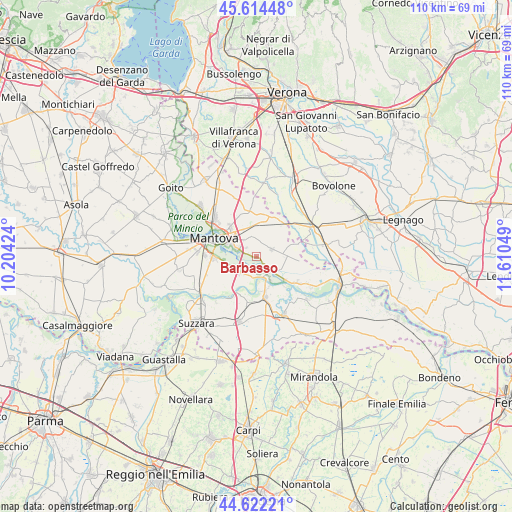
Barbasso GPS coordinates[2]
45° 7' 13.8" North, 10° 54' 26.496" East
| Map corner | latitude | longitude |
|---|---|---|
| Upper-left | 45.61448°, | 10.20424° |
| Center: | 45.1205°, | 10.90736° |
| Lower-right: | 44.62221°, | 11.61049° |
| Map W x H: | 110.3×110.3 km | = 68.5×68.5mi |
| max Lat: | 47.04031° ⇑37% North |
| Barbasso: | 45.1205° |
| min Lat: | ⇓63% South 35.50142° |
| min Long | Barbasso | max Long |
| 6.69888° | 10.90736° | 18.48682° |
| W 41.6%⇐ | ⇒58.4% E |
Elevation
Elevation of Barbasso is 19 m = 62 ft, and this is 287.7 m = 944 ft below average elevation for this country.
| Max E: |
2085 m = 6841 ft | 89.6% |
| Avg. | 306.7 m = 1006 ft | |
| Barbasso | 19 m = 62 ft | |
Min E: |
-4 m = -13 ft | 10.4% |
See also: Italy elevation on elevation.city.
Geographical zone
Barbasso is located in North temperate zone (between Tropic of Cancer and the Arctic Circle). Distance of this North polar circle is 2384.2 km =1481.5 mi to North.| Distance of | km | miles | from Barbasso |
|---|---|---|---|
| North Pole | 4990.1 | 3100.7 | to North |
| Arctic Circle | 2384.2 | 1481.5 | to North |
| Tropic Cancer | 2411 | 1498.1 | to South |
| Equator | 5016.9 | 3117.4 | to South |


Nearby cities:
15 places around Barbasso: (largest is in red/bold)
• Bagnolo San Vito
4.2 km =2.6 mi,  213°
213°
• Castel d'Ario
9.2 km =5.7 mi,  35°
35°
• Castelbelforte
10.2 km =6.3 mi,  353°
353°
• Cerese
9.3 km =5.8 mi,  268°
268°
• Formigosa
3.4 km =2.1 mi,  278°
278°
• Gazzo
6.6 km =4.1 mi, 353°
• Lunetta-Frassino
8.1 km =5 mi,  302°
302°
• Mantova
9.7 km =6 mi, 297°
• Mottella
6.9 km =4.3 mi,  314°
314°
• Pietole
7 km =4.3 mi,  264°
264°
• Roncoferraro
3.4 km =2.1 mi,  54°
54°
• San Benedetto Po
8.5 km =5.3 mi,  165°
165°
• San Biagio
5.3 km =3.3 mi,  243°
243°
• Stradella
6.4 km =4 mi,  335°
335°
• Villimpenta
10 km =6.2 mi,  76°
76°
Sources, notices
• [Note1] Compared only with cities in Italy existing in our database
• [Src1] Map data: © OpenStreetMap contributors (CC-BY-SA)
• [Src2] Other city data from geonames.org with taken over terms of usage.
• [Src3] Geographical zone / Annual Mean Temperature by Robert A. Rohde @ Wikipedia
