Piccione geodata
Piccione (Umbria) is a populated place; located in Italy in Europe/Rome (GMT+2) time zone. With population of 865 people, there are 7340 cities with bigger population in this country. Compared to other cities in Italy, 61.9% of cities are located further ↑North; 62.4% of cities are located further ←West and 60.9% of cities have lower elevation than Piccione. Note1


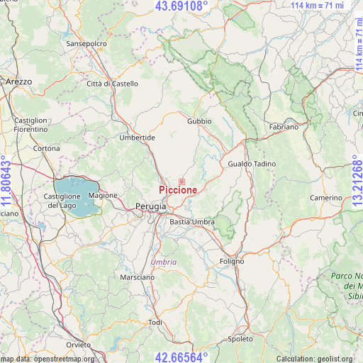
Piccione GPS coordinates[2]
43° 10' 49.836" North, 12° 30' 34.38" East
| Map corner | latitude | longitude |
|---|---|---|
| Upper-left | 43.69108°, | 11.80643° |
| Center: | 43.18051°, | 12.50955° |
| Lower-right: | 42.66564°, | 13.21268° |
| Map W x H: | 114×114 km | = 70.8×70.8mi |
| max Lat: | 47.04031° ⇑61.9% North |
| Piccione: | 43.18051° |
| min Lat: | ⇓38.1% South 35.50142° |
| min Long | Piccione | max Long |
| 6.69888° | 12.50955° | 18.48682° |
| W 62.4%⇐ | ⇒37.6% E |
Elevation
Elevation of Piccione is 306 m = 1004 ft, and this is 0.69999999999999 m = 2 ft below average elevation for this country.
| Max E: |
2085 m = 6841 ft | 39.1% |
| Avg. | 306.7 m = 1006 ft | |
| Piccione | 306 m = 1004 ft | |
Min E: |
-4 m = -13 ft | 60.9% |
See also: Italy elevation on elevation.city.
Geographical zone
Piccione is located in North temperate zone (between Tropic of Cancer and the Arctic Circle). Distance of this Northern Tropic circle is 2195.3 km =1364.1 mi to South.| Distance of | km | miles | from Piccione |
|---|---|---|---|
| North Pole | 5205.8 | 3234.7 | to North |
| Arctic Circle | 2600 | 1615.6 | to North |
| Tropic Cancer | 2195.3 | 1364.1 | to South |
| Equator | 4801.2 | 2983.3 | to South |


Nearby cities:
15 places around Piccione: (largest is in red/bold)
• Casa del Diavolo
5 km =3.1 mi,  279°
279°
• Casacastalda
11.3 km =7 mi,  80°
80°
• Colombella
3.8 km =2.4 mi,  215°
215°
• Fratticiola Selvatica
3.5 km =2.2 mi,  72°
72°
• Osteria di Ramazzano
4 km =2.5 mi,  254°
254°
• Palazzo
10.3 km =6.4 mi,  154°
154°
• Petrignano
8.8 km =5.5 mi,  167°
167°
• Ponte Felcino
7.4 km =4.6 mi, 221°
• Ponte Pattoli
6.6 km =4.1 mi,  267°
267°
• Resina I
7.2 km =4.5 mi,  289°
289°
• Sant'Egidio
8.8 km =5.5 mi,  189°
189°
• Stazione di Parlesca e Solfagnano
8.9 km =5.5 mi,  298°
298°
• Torchiagina
7.1 km =4.4 mi,  163°
163°
• Valfabbrica
7.9 km =4.9 mi,  108°
108°
• Via Lippia
10.7 km =6.6 mi, 192°
Sources, notices
• [Note1] Compared only with cities in Italy existing in our database
• [Src1] Map data: © OpenStreetMap contributors (CC-BY-SA)
• [Src2] Other city data from geonames.org with taken over terms of usage.
• [Src3] Geographical zone / Annual Mean Temperature by Robert A. Rohde @ Wikipedia
