Casacastalda geodata
Casacastalda (Umbria) is a populated place; located in Italy in Europe/Rome (GMT+2) time zone. With population of 624 people, there are 8809 cities with bigger population in this country. Compared to other cities in Italy, 61.8% of cities are located further ↑North; 64.2% of cities are located further ←West and 79.8% of cities have lower elevation than Casacastalda. Note1


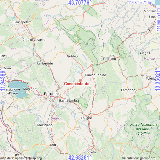
Casacastalda GPS coordinates[2]
43° 11' 50.424" North, 12° 38' 49.488" East
| Map corner | latitude | longitude |
|---|---|---|
| Upper-left | 43.70776°, | 11.94396° |
| Center: | 43.19734°, | 12.64708° |
| Lower-right: | 42.68261°, | 13.35021° |
| Map W x H: | 114×114 km | = 70.8×70.8mi |
| max Lat: | 47.04031° ⇑61.8% North |
| Casacastalda: | 43.19734° |
| min Lat: | ⇓38.2% South 35.50142° |
| min Long | Casacastalda | max Long |
| 6.69888° | 12.64708° | 18.48682° |
| W 64.2%⇐ | ⇒35.8% E |
Elevation
Elevation of Casacastalda is 523 m = 1716 ft, and this is 216.3 m = 710 ft above average elevation for this country.
| Max E: |
2085 m = 6841 ft | 20.2% |
| Casacastalda | 523 m 1716 ft | |
| Avg. | 306.7 m = 1006 ft | |
Min E: |
-4 m = -13 ft | 79.8% |
See also: Italy elevation on elevation.city.
Geographical zone
Casacastalda is located in North temperate zone (between Tropic of Cancer and the Arctic Circle). Distance of this Northern Tropic circle is 2197.2 km =1365.3 mi to South.| Distance of | km | miles | from Casacastalda |
|---|---|---|---|
| North Pole | 5204 | 3233.6 | to North |
| Arctic Circle | 2598.1 | 1614.4 | to North |
| Tropic Cancer | 2197.2 | 1365.3 | to South |
| Equator | 4803.1 | 2984.5 | to South |


Nearby cities:
15 places around Casacastalda: (largest is in red/bold)
• Branca
8.9 km =5.5 mi,  18°
18°
• Casanova di Torre
10.6 km =6.6 mi,  5°
5°
• Cerqueto
9.1 km =5.7 mi,  64°
64°
• Colombella
14.2 km =8.8 mi,  249°
249°
• Fratticiola Selvatica
7.8 km =4.8 mi,  264°
264°
• Gualdo Tadino
11.2 km =7 mi,  71°
71°
• Osteria del Gatto
12.6 km =7.8 mi,  39°
39°
• Palazzo
13 km =8.1 mi,  211°
211°
• Palazzo Mancinelli-Vaccara
11.6 km =7.2 mi,  53°
53°
• Petrignano
14 km =8.7 mi,  221°
221°
• Piccione
11.3 km =7 mi, 260°
• Ponte d'Assi
13.8 km =8.6 mi,  335°
335°
• Stazione di Padule
12.5 km =7.8 mi,  348°
348°
• Torchiagina
12.6 km =7.8 mi,  226°
226°
• Valfabbrica
5.7 km =3.5 mi, 219°
Sources, notices
• [Note1] Compared only with cities in Italy existing in our database
• [Src1] Map data: © OpenStreetMap contributors (CC-BY-SA)
• [Src2] Other city data from geonames.org with taken over terms of usage.
• [Src3] Geographical zone / Annual Mean Temperature by Robert A. Rohde @ Wikipedia
