Pegolotte geodata
Pegolotte (Veneto) is a seat of a third-order administrative division; located in Italy in Europe/Rome (GMT+2) time zone. With population of 1,346 people, there are 5495 cities with bigger population in this country. Compared to other cities in Italy, 64.7% of cities are located further ↓South; 56.4% of cities are located further ←West and 97.2% of cities have higher elevation than Pegolotte. Note1


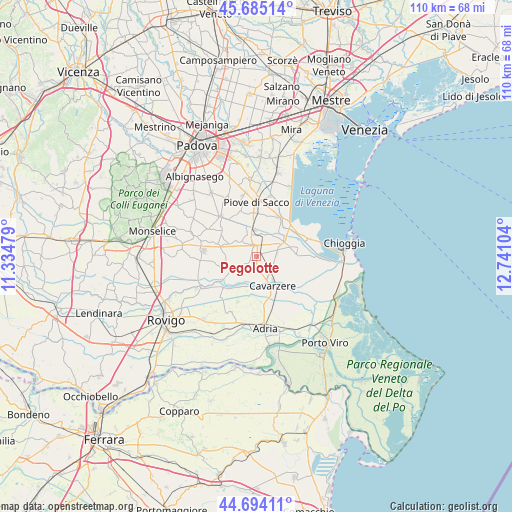
Pegolotte GPS coordinates[2]
45° 11' 30.408" North, 12° 2' 16.476" East
| Map corner | latitude | longitude |
|---|---|---|
| Upper-left | 45.68514°, | 11.33479° |
| Center: | 45.19178°, | 12.03791° |
| Lower-right: | 44.69411°, | 12.74104° |
| Map W x H: | 110.2×110.2 km | = 68.5×68.5mi |
| max Lat: | 47.04031° ⇑35.3% North |
| Pegolotte: | 45.19178° |
| min Lat: | ⇓64.7% South 35.50142° |
| min Long | Pegolotte | max Long |
| 6.69888° | 12.03791° | 18.48682° |
| W 56.4%⇐ | ⇒43.6% E |
Elevation
Elevation of Pegolotte is 5 m = 16 ft, and this is 301.7 m = 990 ft below average elevation for this country.
| Max E: |
2085 m = 6841 ft | 97.2% |
| Avg. | 306.7 m = 1006 ft | |
| Pegolotte | 5 m = 16 ft | |
Min E: |
-4 m = -13 ft | 2.8% |
See also: Italy elevation on elevation.city.
Geographical zone
Pegolotte is located in North temperate zone (between Tropic of Cancer and the Arctic Circle). Distance of this North polar circle is 2376.3 km =1476.6 mi to North.| Distance of | km | miles | from Pegolotte |
|---|---|---|---|
| North Pole | 4982.2 | 3095.8 | to North |
| Arctic Circle | 2376.3 | 1476.6 | to North |
| Tropic Cancer | 2418.9 | 1503 | to South |
| Equator | 5024.9 | 3122.3 | to South |


Nearby cities:
15 places around Pegolotte: (largest is in red/bold)
• Agna
6.8 km =4.2 mi,  249°
249°
• Arre
9 km =5.6 mi,  288°
288°
• Arzerello
9.2 km =5.7 mi,  353°
353°
• Arzergrande
9 km =5.6 mi,  5°
5°
• Boscochiaro
9 km =5.6 mi,  133°
133°
• Candiana
4.9 km =3 mi,  313°
313°
• Cavarzere
7.3 km =4.5 mi,  149°
149°
• Civé
8.9 km =5.5 mi,  78°
78°
• Correzzola
5.4 km =3.4 mi,  25°
25°
• Pettorazza Grimani
7.4 km =4.6 mi,  212°
212°
• Pontelongo
6.1 km =3.8 mi, 351°
• Rottanova
5.6 km =3.5 mi,  195°
195°
• Vallonga
9.5 km =5.9 mi,  19°
19°
• Villa del Bosco
2.7 km =1.7 mi, 348°
• Villaggio Busonera
6.8 km =4.2 mi,  137°
137°
Sources, notices
• [Note1] Compared only with cities in Italy existing in our database
• [Src1] Map data: © OpenStreetMap contributors (CC-BY-SA)
• [Src2] Other city data from geonames.org with taken over terms of usage.
• [Src3] Geographical zone / Annual Mean Temperature by Robert A. Rohde @ Wikipedia
