Arre geodata
Arre (Veneto) is a seat of a third-order administrative division; located in Italy in Europe/Rome (GMT+2) time zone. With population of 1,327 people, there are 5549 cities with bigger population in this country. Compared to other cities in Italy, 65.4% of cities are located further ↓South; 54.9% of cities are located further ←West and 97.8% of cities have higher elevation than Arre. Note1


Arre GPS coordinates[2]
45° 13' 2.928" North, 11° 55' 42.888" East
| Map corner | latitude | longitude |
|---|---|---|
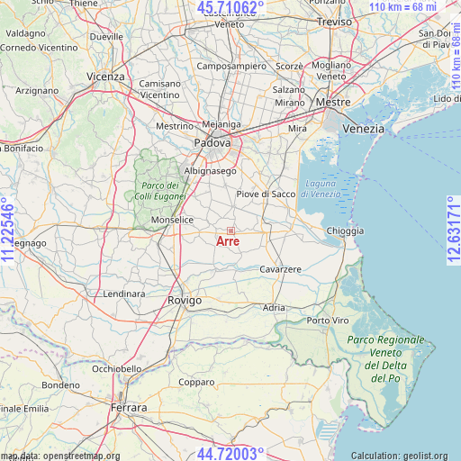
| Upper-left | 45.71062°, | 11.22546° |
| Center: | 45.21748°, | 11.92858° |
| Lower-right: | 44.72003°, | 12.63171° |
| Map W x H: | 110.1×110.1 km | = 68.4×68.4mi |
| max Lat: | 47.04031° ⇑34.6% North |
| Arre: | 45.21748° |
| min Lat: | ⇓65.4% South 35.50142° |
| min Long | Arre | max Long |
| 6.69888° | 11.92858° | 18.48682° |
| W 54.9%⇐ | ⇒45.1% E |
Elevation
Elevation of Arre is 4 m = 13 ft, and this is 302.7 m = 993 ft below average elevation for this country.
| Max E: |
2085 m = 6841 ft | 97.8% |
| Avg. | 306.7 m = 1006 ft | |
| Arre | 4 m = 13 ft | |
Min E: |
-4 m = -13 ft | 2.2% |
See also: Italy elevation on elevation.city.
Geographical zone
Arre is located in North temperate zone (between Tropic of Cancer and the Arctic Circle). Distance of this North polar circle is 2373.5 km =1474.8 mi to North.| Distance of | km | miles | from Arre |
|---|---|---|---|
| North Pole | 4979.3 | 3094 | to North |
| Arctic Circle | 2373.5 | 1474.8 | to North |
| Tropic Cancer | 2421.8 | 1504.8 | to South |
| Equator | 5027.7 | 3124.1 | to South |


Nearby cities:
15 places around Arre: (largest is in red/bold)
• Agna
5.7 km =3.5 mi,  157°
157°
• Anguillara Veneta
9 km =5.6 mi,  202°
202°
• Arzercavalli
3.1 km =1.9 mi,  15°
15°
• Bagnoli di Sopra
4.9 km =3 mi,  225°
225°
• Bovolenta
5.7 km =3.5 mi,  5°
5°
• Cagnola
8.6 km =5.3 mi,  326°
326°
• Campagnola
8.8 km =5.5 mi,  39°
39°
• Candiana
5 km =3.1 mi,  84°
84°
• Cartura
8 km =5 mi,  315°
315°
• Conselve
4.5 km =2.8 mi,  290°
290°
• Pegolotte
9 km =5.6 mi,  108°
108°
• Pontelongo
8.2 km =5.1 mi,  67°
67°
• Terrassa Padovana
3.6 km =2.2 mi, 325°
• Tribano
7.3 km =4.5 mi,  262°
262°
• Villa del Bosco
8 km =5 mi,  91°
91°
Sources, notices
• [Note1] Compared only with cities in Italy existing in our database
• [Src1] Map data: © OpenStreetMap contributors (CC-BY-SA)
• [Src2] Other city data from geonames.org with taken over terms of usage.
• [Src3] Geographical zone / Annual Mean Temperature by Robert A. Rohde @ Wikipedia
