Rottanova geodata
Rottanova (Veneto) is a populated place; located in Italy in Europe/Rome (GMT+2) time zone. With population of 1,046 people, there are 6479 cities with bigger population in this country. Compared to other cities in Italy, 63.6% of cities are located further ↓South; 56.1% of cities are located further ←West and 99.4% of cities have higher elevation than Rottanova. Note1


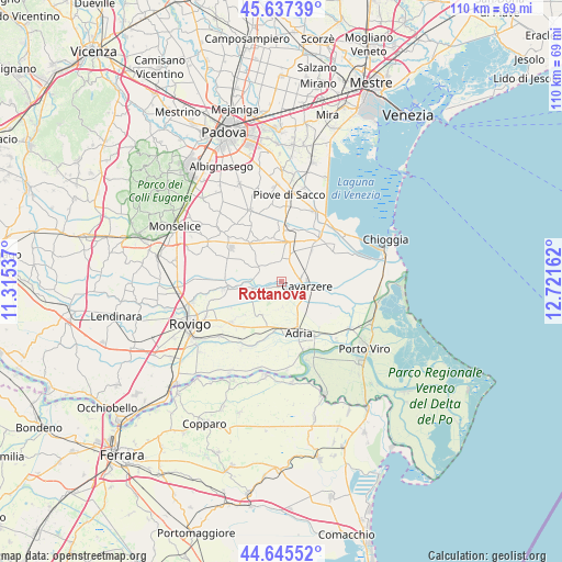
Rottanova GPS coordinates[2]
45° 8' 36.996" North, 12° 1' 6.564" East
| Map corner | latitude | longitude |
|---|---|---|
| Upper-left | 45.63739°, | 11.31537° |
| Center: | 45.14361°, | 12.01849° |
| Lower-right: | 44.64552°, | 12.72162° |
| Map W x H: | 110.3×110.3 km | = 68.5×68.5mi |
| max Lat: | 47.04031° ⇑36.4% North |
| Rottanova: | 45.14361° |
| min Lat: | ⇓63.6% South 35.50142° |
| min Long | Rottanova | max Long |
| 6.69888° | 12.01849° | 18.48682° |
| W 56.1%⇐ | ⇒43.9% E |
Elevation
Elevation of Rottanova is 1 m = 3 ft, and this is 305.7 m = 1003 ft below average elevation for this country.
| Max E: |
2085 m = 6841 ft | 99.4% |
| Avg. | 306.7 m = 1006 ft | |
| Rottanova | 1 m = 3 ft | |
Min E: |
-4 m = -13 ft | 0.6% |
See also: Italy elevation on elevation.city.
Geographical zone
Rottanova is located in North temperate zone (between Tropic of Cancer and the Arctic Circle). Distance of this North polar circle is 2381.7 km =1479.9 mi to North.| Distance of | km | miles | from Rottanova |
|---|---|---|---|
| North Pole | 4987.6 | 3099.1 | to North |
| Arctic Circle | 2381.7 | 1479.9 | to North |
| Tropic Cancer | 2413.6 | 1499.7 | to South |
| Equator | 5019.5 | 3119 | to South |


Nearby cities:
15 places around Rottanova: (largest is in red/bold)
• Adria
10.3 km =6.4 mi,  163°
163°
• Agna
5.7 km =3.5 mi,  301°
301°
• Anguillara Veneta
10.5 km =6.5 mi,  269°
269°
• Arre
10.8 km =6.7 mi,  319°
319°
• Baricetta
9.7 km =6 mi,  189°
189°
• Beverare
5.9 km =3.7 mi,  258°
258°
• Boscochiaro
8.1 km =5 mi,  95°
95°
• Candiana
8.9 km =5.5 mi,  346°
346°
• Cavarzere
5.3 km =3.3 mi, 100°
• Correzzola
10.9 km =6.8 mi,  20°
20°
• Pegolotte
5.6 km =3.5 mi, 15°
• Pettorazza Grimani
2.6 km =1.6 mi,  250°
250°
• Valliera
9.2 km =5.7 mi,  181°
181°
• Villa del Bosco
8.1 km =5 mi,  6°
6°
• Villaggio Busonera
6.1 km =3.8 mi,  86°
86°
Sources, notices
• [Note1] Compared only with cities in Italy existing in our database
• [Src1] Map data: © OpenStreetMap contributors (CC-BY-SA)
• [Src2] Other city data from geonames.org with taken over terms of usage.
• [Src3] Geographical zone / Annual Mean Temperature by Robert A. Rohde @ Wikipedia
