Agna geodata
Agna (Veneto) is a seat of a third-order administrative division; located in Italy in Europe/Rome (GMT+2) time zone. With population of 2,909 people, there are 3114 cities with bigger population in this country. Compared to other cities in Italy, 64.3% of cities are located further ↓South; 55.3% of cities are located further ←West and 99.4% of cities have higher elevation than Agna. Note1


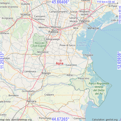
Agna GPS coordinates[2]
45° 10' 13.836" North, 11° 57' 22.5" East
| Map corner | latitude | longitude |
|---|---|---|
| Upper-left | 45.66406°, | 11.25313° |
| Center: | 45.17051°, | 11.95625° |
| Lower-right: | 44.67265°, | 12.65938° |
| Map W x H: | 110.2×110.2 km | = 68.5×68.5mi |
| max Lat: | 47.04031° ⇑35.7% North |
| Agna: | 45.17051° |
| min Lat: | ⇓64.3% South 35.50142° |
| min Long | Agna | max Long |
| 6.69888° | 11.95625° | 18.48682° |
| W 55.3%⇐ | ⇒44.7% E |
Elevation
Elevation of Agna is 1 m = 3 ft, and this is 305.7 m = 1003 ft below average elevation for this country.
| Max E: |
2085 m = 6841 ft | 99.4% |
| Avg. | 306.7 m = 1006 ft | |
| Agna | 1 m = 3 ft | |
Min E: |
-4 m = -13 ft | 0.6% |
See also: Italy elevation on elevation.city.
Geographical zone
Agna is located in North temperate zone (between Tropic of Cancer and the Arctic Circle). Distance of this North polar circle is 2378.7 km =1478.1 mi to North.| Distance of | km | miles | from Agna |
|---|---|---|---|
| North Pole | 4984.6 | 3097.3 | to North |
| Arctic Circle | 2378.7 | 1478.1 | to North |
| Tropic Cancer | 2416.6 | 1501.6 | to South |
| Equator | 5022.5 | 3120.8 | to South |


Nearby cities:
15 places around Agna: (largest is in red/bold)
• Anguillara Veneta
6.4 km =4 mi,  240°
240°
• Arre
5.7 km =3.5 mi,  337°
337°
• Arzercavalli
8.3 km =5.2 mi,  350°
350°
• Bagnoli di Sopra
5.9 km =3.7 mi,  287°
287°
• Beverare
4.3 km =2.7 mi,  191°
191°
• Candiana
6.4 km =4 mi,  26°
26°
• Conselve
9.3 km =5.8 mi,  316°
316°
• Pegolotte
6.8 km =4.2 mi,  69°
69°
• Pettorazza Grimani
4.6 km =2.9 mi,  147°
147°
• Pontelongo
10 km =6.2 mi, 33°
• Rottanova
5.7 km =3.5 mi,  121°
121°
• San Martino di Venezze
8.4 km =5.2 mi,  233°
233°
• Terrassa Padovana
9.2 km =5.7 mi,  332°
332°
• Tribano
10.3 km =6.4 mi, 294°
• Villa del Bosco
7.7 km =4.8 mi,  49°
49°
Sources, notices
• [Note1] Compared only with cities in Italy existing in our database
• [Src1] Map data: © OpenStreetMap contributors (CC-BY-SA)
• [Src2] Other city data from geonames.org with taken over terms of usage.
• [Src3] Geographical zone / Annual Mean Temperature by Robert A. Rohde @ Wikipedia
