Parrano geodata
Parrano (Umbria) is a seat of a third-order administrative division; located in Italy in Europe/Rome (GMT+2) time zone. With population of 334 people, there are 10537 cities with bigger population in this country. Compared to other cities in Italy, 64.3% of cities are located further ↑North; 57.5% of cities are located further ←West and 75.3% of cities have lower elevation than Parrano. Note1


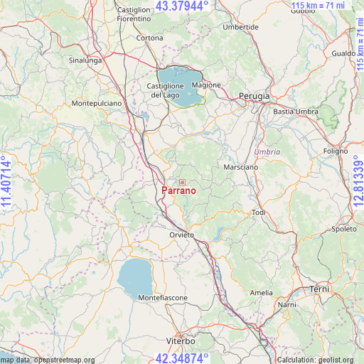
Parrano GPS coordinates[2]
42° 51' 58.464" North, 12° 6' 36.936" East
| Map corner | latitude | longitude |
|---|---|---|
| Upper-left | 43.37944°, | 11.40714° |
| Center: | 42.86624°, | 12.11026° |
| Lower-right: | 42.34874°, | 12.81339° |
| Map W x H: | 114.6×114.6 km | = 71.2×71.2mi |
| max Lat: | 47.04031° ⇑64.3% North |
| Parrano: | 42.86624° |
| min Lat: | ⇓35.7% South 35.50142° |
| min Long | Parrano | max Long |
| 6.69888° | 12.11026° | 18.48682° |
| W 57.5%⇐ | ⇒42.5% E |
Elevation
Elevation of Parrano is 456 m = 1496 ft, and this is 149.3 m = 490 ft above average elevation for this country.
| Max E: |
2085 m = 6841 ft | 24.7% |
| Parrano | 456 m 1496 ft | |
| Avg. | 306.7 m = 1006 ft | |
Min E: |
-4 m = -13 ft | 75.3% |
See also: Italy elevation on elevation.city.
Geographical zone
Parrano is located in North temperate zone (between Tropic of Cancer and the Arctic Circle). Distance of this Northern Tropic circle is 2160.4 km =1342.4 mi to South.| Distance of | km | miles | from Parrano |
|---|---|---|---|
| North Pole | 5240.8 | 3256.5 | to North |
| Arctic Circle | 2634.9 | 1637.3 | to North |
| Tropic Cancer | 2160.4 | 1342.4 | to South |
| Equator | 4766.3 | 2961.6 | to South |


Nearby cities:
15 places around Parrano: (largest is in red/bold)
• Allerona
12.6 km =7.8 mi,  241°
241°
• Ciconia
14.9 km =9.3 mi,  172°
172°
• Città della Pieve
13.3 km =8.3 mi,  320°
320°
• Fabro
7.8 km =4.8 mi,  275°
275°
• Fabro Scalo
5.3 km =3.3 mi, 281°
• Ficulle
5.1 km =3.2 mi,  222°
222°
• Montegabbione
6.1 km =3.8 mi,  346°
346°
• Monteleone d'Orvieto
7.7 km =4.8 mi, 323°
• Monterubiaglio
13.4 km =8.3 mi,  214°
214°
• Pianlungo
11.2 km =7 mi, 212°
• Piegaro
11.3 km =7 mi, 349°
• Ponticelli
13.2 km =8.2 mi,  303°
303°
• San Venanzo
12.9 km =8 mi,  88°
88°
• Santa Maria
6.6 km =4.1 mi, 296°
• Stazione di Allerona
10.8 km =6.7 mi, 213°
Sources, notices
• [Note1] Compared only with cities in Italy existing in our database
• [Src1] Map data: © OpenStreetMap contributors (CC-BY-SA)
• [Src2] Other city data from geonames.org with taken over terms of usage.
• [Src3] Geographical zone / Annual Mean Temperature by Robert A. Rohde @ Wikipedia
