San Venanzo geodata
San Venanzo (Umbria) is a seat of a third-order administrative division; located in Italy in Europe/Rome (GMT+2) time zone. With population of 980 people, there are 6738 cities with bigger population in this country. Compared to other cities in Italy, 64.2% of cities are located further ↑North; 59.5% of cities are located further ←West and 75.4% of cities have lower elevation than San Venanzo. Note1


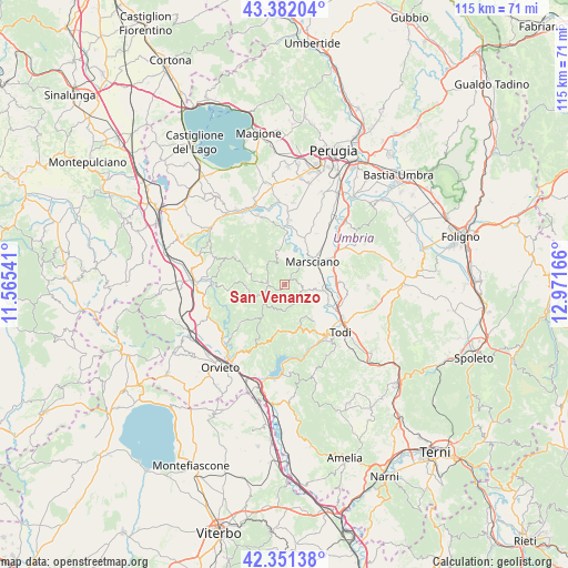
San Venanzo GPS coordinates[2]
42° 52' 7.896" North, 12° 16' 6.708" East
| Map corner | latitude | longitude |
|---|---|---|
| Upper-left | 43.38204°, | 11.56541° |
| Center: | 42.86886°, | 12.26853° |
| Lower-right: | 42.35138°, | 12.97166° |
| Map W x H: | 114.6×114.6 km | = 71.2×71.2mi |
| max Lat: | 47.04031° ⇑64.2% North |
| San Venanzo: | 42.86886° |
| min Lat: | ⇓35.8% South 35.50142° |
| min Long | San Venanzo | max Long |
| 6.69888° | 12.26853° | 18.48682° |
| W 59.5%⇐ | ⇒40.5% E |
Elevation
Elevation of San Venanzo is 457 m = 1499 ft, and this is 150.3 m = 493 ft above average elevation for this country.
| Max E: |
2085 m = 6841 ft | 24.6% |
| San Venanzo | 457 m 1499 ft | |
| Avg. | 306.7 m = 1006 ft | |
Min E: |
-4 m = -13 ft | 75.4% |
See also: Italy elevation on elevation.city.
Geographical zone
San Venanzo is located in North temperate zone (between Tropic of Cancer and the Arctic Circle). Distance of this Northern Tropic circle is 2160.7 km =1342.6 mi to South.| Distance of | km | miles | from San Venanzo |
|---|---|---|---|
| North Pole | 5240.5 | 3256.3 | to North |
| Arctic Circle | 2634.6 | 1637.1 | to North |
| Tropic Cancer | 2160.7 | 1342.6 | to South |
| Equator | 4766.6 | 2961.8 | to South |


Nearby cities:
15 places around San Venanzo: (largest is in red/bold)
• Cerqueto
10.1 km =6.3 mi,  23°
23°
• Collazzone
14.1 km =8.8 mi,  75°
75°
• Collepepe
11.5 km =7.1 mi,  63°
63°
• Fratta Todina
7.9 km =4.9 mi,  99°
99°
• Marsciano
8.8 km =5.5 mi,  49°
49°
• Monte Castello di Vibio
7.5 km =4.7 mi,  114°
114°
• Montegabbione
15.4 km =9.6 mi,  291°
291°
• Pantalla
10.6 km =6.6 mi,  87°
87°
• Parrano
12.9 km =8 mi,  268°
268°
• Pietrafitta
14.3 km =8.9 mi,  341°
341°
• Ponterio-Pian di Porto
13.4 km =8.3 mi,  120°
120°
• Ripabianca
13.5 km =8.4 mi, 54°
• San Terenziano
16.7 km =10.4 mi, 90°
• Spina
13 km =8.1 mi,  4°
4°
• Todi
15.4 km =9.6 mi,  130°
130°
Sources, notices
• [Note1] Compared only with cities in Italy existing in our database
• [Src1] Map data: © OpenStreetMap contributors (CC-BY-SA)
• [Src2] Other city data from geonames.org with taken over terms of usage.
• [Src3] Geographical zone / Annual Mean Temperature by Robert A. Rohde @ Wikipedia
