Ficulle geodata
Ficulle (Umbria) is a seat of a third-order administrative division; located in Italy in Europe/Rome (GMT+2) time zone. With population of 848 people, there are 7415 cities with bigger population in this country. Compared to other cities in Italy, 64.5% of cities are located further ↑North; 56.8% of cities are located further ←West and 75.2% of cities have lower elevation than Ficulle. Note1


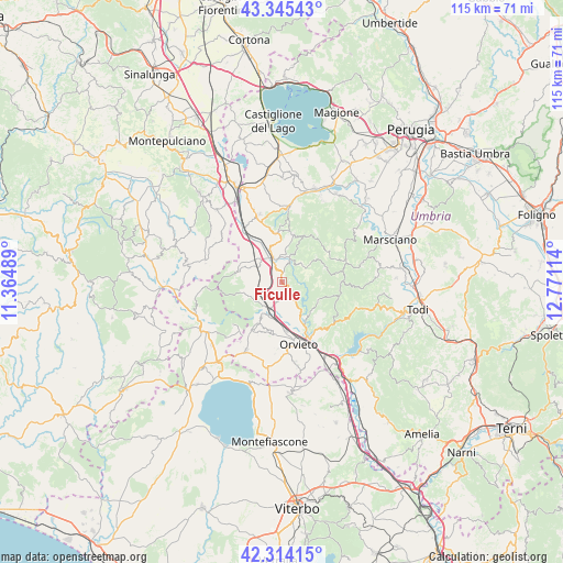
Ficulle GPS coordinates[2]
42° 49' 54.984" North, 12° 4' 4.836" East
| Map corner | latitude | longitude |
|---|---|---|
| Upper-left | 43.34543°, | 11.36489° |
| Center: | 42.83194°, | 12.06801° |
| Lower-right: | 42.31415°, | 12.77114° |
| Map W x H: | 114.7×114.7 km | = 71.3×71.3mi |
| max Lat: | 47.04031° ⇑64.5% North |
| Ficulle: | 42.83194° |
| min Lat: | ⇓35.5% South 35.50142° |
| min Long | Ficulle | max Long |
| 6.69888° | 12.06801° | 18.48682° |
| W 56.8%⇐ | ⇒43.2% E |
Elevation
Elevation of Ficulle is 454 m = 1490 ft, and this is 147.3 m = 483 ft above average elevation for this country.
| Max E: |
2085 m = 6841 ft | 24.8% |
| Ficulle | 454 m 1490 ft | |
| Avg. | 306.7 m = 1006 ft | |
Min E: |
-4 m = -13 ft | 75.2% |
See also: Italy elevation on elevation.city.
Geographical zone
Ficulle is located in North temperate zone (between Tropic of Cancer and the Arctic Circle). Distance of this Northern Tropic circle is 2156.5 km =1340 mi to South.| Distance of | km | miles | from Ficulle |
|---|---|---|---|
| North Pole | 5244.6 | 3258.8 | to North |
| Arctic Circle | 2638.7 | 1639.6 | to North |
| Tropic Cancer | 2156.5 | 1340 | to South |
| Equator | 4762.5 | 2959.3 | to South |


Nearby cities:
15 places around Ficulle: (largest is in red/bold)
• Allerona
7.9 km =4.9 mi,  253°
253°
• Castel Viscardo
10.3 km =6.4 mi,  212°
212°
• Ciconia
12.2 km =7.6 mi,  153°
153°
• Fabro
6.2 km =3.9 mi,  316°
316°
• Fabro Scalo
5.2 km =3.2 mi,  340°
340°
• Montegabbione
10 km =6.2 mi,  11°
11°
• Monteleone d'Orvieto
10.1 km =6.3 mi,  353°
353°
• Monterubiaglio
8.4 km =5.2 mi, 209°
• Orvieto
13 km =8.1 mi,  163°
163°
• Parrano
5.1 km =3.2 mi,  42°
42°
• Pianlungo
6.2 km =3.9 mi, 205°
• Ponticelli
13.4 km =8.3 mi,  325°
325°
• Santa Maria
7.2 km =4.5 mi, 340°
• Sferracavallo
12 km =7.5 mi,  169°
169°
• Stazione di Allerona
5.7 km =3.5 mi, 205°
Sources, notices
• [Note1] Compared only with cities in Italy existing in our database
• [Src1] Map data: © OpenStreetMap contributors (CC-BY-SA)
• [Src2] Other city data from geonames.org with taken over terms of usage.
• [Src3] Geographical zone / Annual Mean Temperature by Robert A. Rohde @ Wikipedia
