Comano geodata
Comano (Tuscany) is a seat of a third-order administrative division; located in Italy in Europe/Rome (GMT+2) time zone. With population of 277 people, there are 10771 cities with bigger population in this country. Compared to other cities in Italy, 52% of cities are located further ↑North; 66.6% of cities are located further →East and 80.7% of cities have lower elevation than Comano. Note1


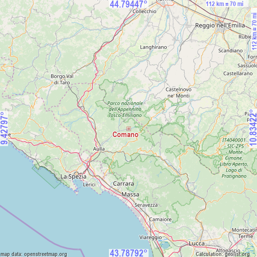
Comano GPS coordinates[2]
44° 17' 36.06" North, 10° 7' 51.924" East
| Map corner | latitude | longitude |
|---|---|---|
| Upper-left | 44.79447°, | 9.42797° |
| Center: | 44.29335°, | 10.13109° |
| Lower-right: | 43.78792°, | 10.83422° |
| Map W x H: | 111.9×111.9 km | = 69.5×69.5mi |
| max Lat: | 47.04031° ⇑52% North |
| Comano: | 44.29335° |
| min Lat: | ⇓48% South 35.50142° |
| min Long | Comano | max Long |
| 6.69888° | 10.13109° | 18.48682° |
| W 33.4%⇐ | ⇒66.6% E |
Elevation
Elevation of Comano is 535 m = 1755 ft, and this is 228.3 m = 749 ft above average elevation for this country.
| Max E: |
2085 m = 6841 ft | 19.3% |
| Comano | 535 m 1755 ft | |
| Avg. | 306.7 m = 1006 ft | |
Min E: |
-4 m = -13 ft | 80.7% |
See also: Italy elevation on elevation.city.
Geographical zone
Comano is located in North temperate zone (between Tropic of Cancer and the Arctic Circle). Distance of this Northern Tropic circle is 2319 km =1441 mi to South.| Distance of | km | miles | from Comano |
|---|---|---|---|
| North Pole | 5082.1 | 3157.9 | to North |
| Arctic Circle | 2476.2 | 1538.6 | to North |
| Tropic Cancer | 2319 | 1441 | to South |
| Equator | 4925 | 3060.3 | to South |


Nearby cities:
15 places around Comano: (largest is in red/bold)
• Bagnone
11.1 km =6.9 mi,  282°
282°
• Casola in Lunigiana
11 km =6.8 mi,  160°
160°
• Collagna
12.8 km =8 mi,  62°
62°
• Fivizzano
6.2 km =3.9 mi,  183°
183°
• Giuncugnano
13 km =8.1 mi,  134°
134°
• Gragnola
11.1 km =6.9 mi,  188°
188°
• Licciana Nardi
8.1 km =5 mi,  246°
246°
• Masero
14.8 km =9.2 mi,  240°
240°
• Minucciano
15 km =9.3 mi, 155°
• Monchio delle Corti
13.2 km =8.2 mi,  357°
357°
• Monti
11 km =6.8 mi, 243°
• Monzone
14.3 km =8.9 mi, 181°
• Pallerone
14.2 km =8.8 mi,  226°
226°
• Terrarossa
15.1 km =9.4 mi, 243°
• Villafranca in Lunigiana
14.1 km =8.8 mi,  272°
272°
Sources, notices
• [Note1] Compared only with cities in Italy existing in our database
• [Src1] Map data: © OpenStreetMap contributors (CC-BY-SA)
• [Src2] Other city data from geonames.org with taken over terms of usage.
• [Src3] Geographical zone / Annual Mean Temperature by Robert A. Rohde @ Wikipedia
