Ligonchio geodata
Ligonchio (Emilia-Romagna) is a seat of a third-order administrative division; located in Italy in Europe/Rome (GMT+2) time zone. With population of 257 people, there are 10860 cities with bigger population in this country. Compared to other cities in Italy, 51.7% of cities are located further ↑North; 64.6% of cities are located further →East and 96.6% of cities have lower elevation than Ligonchio. Note1
Administrative division(s):
- Level 1: Emilia-Romagna
- Level 2: Provincia di Reggio Emilia
- Level 3: Ventasso


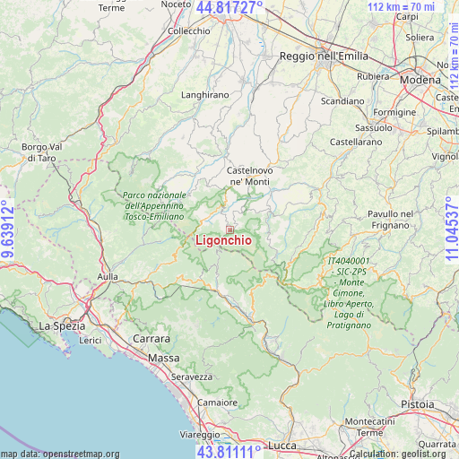
Ligonchio GPS coordinates[2]
44° 18' 58.86" North, 10° 20' 32.064" East
| Map corner | latitude | longitude |
|---|---|---|
| Upper-left | 44.81727°, | 9.63912° |
| Center: | 44.31635°, | 10.34224° |
| Lower-right: | 43.81111°, | 11.04537° |
| Map W x H: | 111.9×111.9 km | = 69.5×69.5mi |
| max Lat: | 47.04031° ⇑51.7% North |
| Ligonchio: | 44.31635° |
| min Lat: | ⇓48.3% South 35.50142° |
| min Long | Ligonchio | max Long |
| 6.69888° | 10.34224° | 18.48682° |
| W 35.4%⇐ | ⇒64.6% E |
Elevation
Elevation of Ligonchio is 976 m = 3202 ft, and this is 669.3 m = 2196 ft above average elevation for this country.
| Max E: |
2085 m = 6841 ft | 3.4% |
| Ligonchio | 976 m 3202 ft | |
| Avg. | 306.7 m = 1006 ft | |
Min E: |
-4 m = -13 ft | 96.6% |
See also: Italy elevation on elevation.city.
Geographical zone
Ligonchio is located in North temperate zone (between Tropic of Cancer and the Arctic Circle). Distance of this Northern Tropic circle is 2321.6 km =1442.6 mi to South.| Distance of | km | miles | from Ligonchio |
|---|---|---|---|
| North Pole | 5079.5 | 3156.3 | to North |
| Arctic Circle | 2473.7 | 1537.1 | to North |
| Tropic Cancer | 2321.6 | 1442.6 | to South |
| Equator | 4927.5 | 3061.8 | to South |


Nearby cities:
15 places around Ligonchio: (largest is in red/bold)
• Busana
6 km =3.7 mi,  345°
345°
• Camporgiano
17.5 km =10.9 mi,  182°
182°
• Castelnovo ne'Monti
14.1 km =8.8 mi,  20°
20°
• Cavola
17.7 km =11 mi,  58°
58°
• Cervarezza
8.2 km =5.1 mi, 353°
• Collagna
6.4 km =4 mi,  301°
301°
• Comano
17 km =10.6 mi,  261°
261°
• Giuncugnano
14 km =8.7 mi,  212°
212°
• Palanzano
17.8 km =11.1 mi,  318°
318°
• Piazza al Serchio-San Michele
15.1 km =9.4 mi,  193°
193°
• Ramiseto
11.9 km =7.4 mi,  334°
334°
• San Romano
16.2 km =10.1 mi, 178°
• San Romano in Garfagnana
16.3 km =10.1 mi, 178°
• Sillano
10.9 km =6.8 mi,  197°
197°
• Villa Minozzo
11.2 km =7 mi, 61°
Sources, notices
• [Note1] Compared only with cities in Italy existing in our database
• [Src1] Map data: © OpenStreetMap contributors (CC-BY-SA)
• [Src2] Other city data from geonames.org with taken over terms of usage.
• [Src3] Geographical zone / Annual Mean Temperature by Robert A. Rohde @ Wikipedia
