Monchio delle Corti geodata
Monchio delle Corti (Emilia-Romagna) is a seat of a third-order administrative division; located in Italy in Europe/Rome (GMT+2) time zone. With population of 230 people, there are 10980 cities with bigger population in this country. Compared to other cities in Italy, 50.3% of cities are located further ↑North; 66.6% of cities are located further →East and 93.5% of cities have lower elevation than Monchio delle Corti. Note1
Administrative division(s):
- Level 1: Emilia-Romagna
- Level 2: Provincia di Parma
- Level 3: Monchio delle Corti


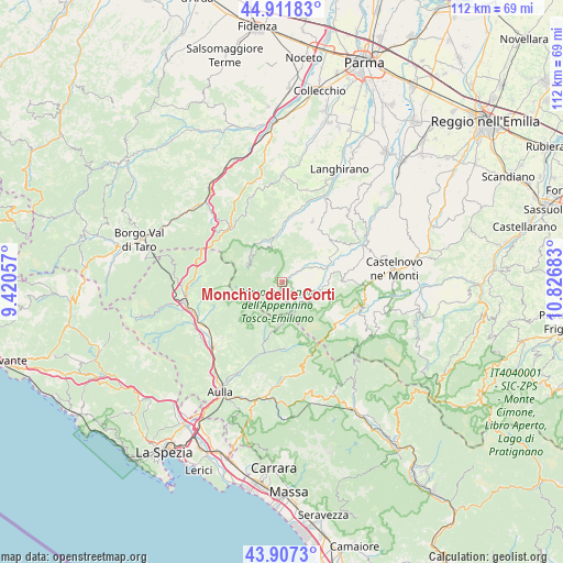
Monchio delle Corti GPS coordinates[2]
44° 24' 42.192" North, 10° 7' 25.32" East
| Map corner | latitude | longitude |
|---|---|---|
| Upper-left | 44.91183°, | 9.42057° |
| Center: | 44.41172°, | 10.1237° |
| Lower-right: | 43.9073°, | 10.82683° |
| Map W x H: | 111.7×111.7 km | = 69.4×69.4mi |
| max Lat: | 47.04031° ⇑50.3% North |
| Monchio delle Corti: | 44.41172° |
| min Lat: | ⇓49.7% South 35.50142° |
| min Long | Monchio delle C | max Long |
| 6.69888° | 10.1237° | 18.48682° |
| W 33.4%⇐ | ⇒66.6% E |
Elevation
Elevation of Monchio delle Corti is 815 m = 2674 ft, and this is 508.3 m = 1668 ft above average elevation for this country.
| Max E: |
2085 m = 6841 ft | 6.5% |
| Monchio delle Corti | 815 m 2674 ft | |
| Avg. | 306.7 m = 1006 ft | |
Min E: |
-4 m = -13 ft | 93.5% |
See also: Italy elevation on elevation.city.
Geographical zone
Monchio delle Corti is located in North temperate zone (between Tropic of Cancer and the Arctic Circle). Distance of this Northern Tropic circle is 2332.2 km =1449.2 mi to South.| Distance of | km | miles | from Monchio delle Corti |
|---|---|---|---|
| North Pole | 5068.9 | 3149.7 | to North |
| Arctic Circle | 2463.1 | 1530.5 | to North |
| Tropic Cancer | 2332.2 | 1449.2 | to South |
| Equator | 4938.1 | 3068.4 | to South |


Nearby cities:
15 places around Monchio delle Corti: (largest is in red/bold)
• Bagnone
14.8 km =9.2 mi,  223°
223°
• Berceto
15.1 km =9.4 mi,  315°
315°
• Busana
16.6 km =10.3 mi,  106°
106°
• Cervarezza
16.6 km =10.3 mi,  98°
98°
• Collagna
13.9 km =8.6 mi,  121°
121°
• Comano
13.2 km =8.2 mi,  177°
177°
• Corniglio
7.4 km =4.6 mi,  339°
339°
• Filattiera
17.7 km =11 mi,  239°
239°
• Fivizzano
19.3 km =12 mi, 179°
• Licciana Nardi
17.7 km =11 mi,  202°
202°
• Palanzano
6.2 km =3.9 mi,  63°
63°
• Ramiseto
12.2 km =7.6 mi,  89°
89°
• Tizzano Val Parma
13.3 km =8.3 mi,  26°
26°
• Vetto
18.9 km =11.7 mi, 64°
• Villafranca in Lunigiana
18.5 km =11.5 mi,  227°
227°
Sources, notices
• [Note1] Compared only with cities in Italy existing in our database
• [Src1] Map data: © OpenStreetMap contributors (CC-BY-SA)
• [Src2] Other city data from geonames.org with taken over terms of usage.
• [Src3] Geographical zone / Annual Mean Temperature by Robert A. Rohde @ Wikipedia
