Egna geodata
Egna (Trentino-Alto Adige) is a seat of a third-order administrative division; located in Italy in Europe/Rome (GMT+2) time zone. With population of 3,474 people, there are 2698 cities with bigger population in this country. Compared to other cities in Italy, 97% of cities are located further ↓South; 53.5% of cities are located further →East and 51.6% of cities have higher elevation than Egna. Note1


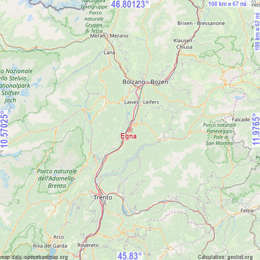
Egna GPS coordinates[2]
46° 19' 3.972" North, 11° 16' 24.132" East
| Map corner | latitude | longitude |
|---|---|---|
| Upper-left | 46.80123°, | 10.57025° |
| Center: | 46.31777°, | 11.27337° |
| Lower-right: | 45.83°, | 11.9765° |
| Map W x H: | 108×108 km | = 67.1×67.1mi |
| max Lat: | 47.04031° ⇑3% North |
| Egna: | 46.31777° |
| min Lat: | ⇓97% South 35.50142° |
| min Long | Egna | max Long |
| 6.69888° | 11.27337° | 18.48682° |
| W 46.5%⇐ | ⇒53.5% E |
Elevation
Elevation of Egna is 224 m = 735 ft, and this is 82.7 m = 271 ft below average elevation for this country.
| Max E: |
2085 m = 6841 ft | 51.6% |
| Avg. | 306.7 m = 1006 ft | |
| Egna | 224 m = 735 ft | |
Min E: |
-4 m = -13 ft | 48.4% |
See also: Italy elevation on elevation.city.
Geographical zone
Egna is located in North temperate zone (between Tropic of Cancer and the Arctic Circle). Distance of this North polar circle is 2251.1 km =1398.8 mi to North.| Distance of | km | miles | from Egna |
|---|---|---|---|
| North Pole | 4857 | 3018 | to North |
| Arctic Circle | 2251.1 | 1398.8 | to North |
| Tropic Cancer | 2544.1 | 1580.8 | to South |
| Equator | 5150.1 | 3200.1 | to South |


Nearby cities:
15 places around Egna: (largest is in red/bold)
• Aldino
8.2 km =5.1 mi,  49°
49°
• Anterivo
8.4 km =5.2 mi,  121°
121°
• Bronzolo
10.2 km =6.3 mi,  20°
20°
• Capriana
7.9 km =4.9 mi,  140°
140°
• Cortaccia sulla Strada del Vino
3.8 km =2.4 mi,  263°
263°
• Cortina sulla Strada del Vino
6.7 km =4.2 mi,  216°
216°
• Grauno
9.9 km =6.2 mi,  168°
168°
• Laghetti
5.4 km =3.4 mi,  208°
208°
• Magrè sulla Strada del Vino
5.8 km =3.6 mi,  235°
235°
• Montagna
2.5 km =1.6 mi,  55°
55°
• Ora
3.7 km =2.3 mi,  29°
29°
• Salorno
9.8 km =6.1 mi, 208°
• Termeno
3.6 km =2.2 mi,  317°
317°
• Trodena
5.9 km =3.7 mi,  85°
85°
• Valfloriana
9.3 km =5.8 mi, 144°
Sources, notices
• [Note1] Compared only with cities in Italy existing in our database
• [Src1] Map data: © OpenStreetMap contributors (CC-BY-SA)
• [Src2] Other city data from geonames.org with taken over terms of usage.
• [Src3] Geographical zone / Annual Mean Temperature by Robert A. Rohde @ Wikipedia
