Novacella geodata
Novacella (Trentino-Alto Adige) is a populated place; located in Italy in Europe/Rome (GMT+2) time zone. With population of 548 people, there are 9471 cities with bigger population in this country. Compared to other cities in Italy, 99.5% of cities are located further ↓South; 51.2% of cities are located further ←West and 84.1% of cities have lower elevation than Novacella. Note1


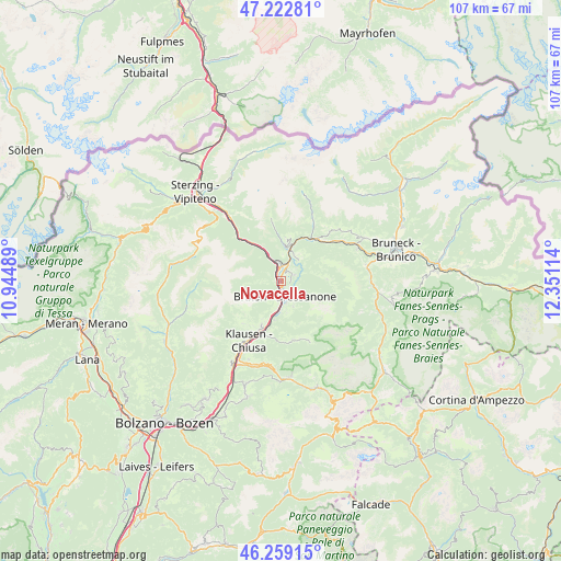
Novacella GPS coordinates[2]
46° 44' 35.268" North, 11° 38' 52.836" East
| Map corner | latitude | longitude |
|---|---|---|
| Upper-left | 47.22281°, | 10.94489° |
| Center: | 46.74313°, | 11.64801° |
| Lower-right: | 46.25915°, | 12.35114° |
| Map W x H: | 107.1×107.1 km | = 66.5×66.5mi |
| max Lat: | 47.04031° ⇑0.5% North |
| Novacella: | 46.74313° |
| min Lat: | ⇓99.5% South 35.50142° |
| min Long | Novacella | max Long |
| 6.69888° | 11.64801° | 18.48682° |
| W 51.2%⇐ | ⇒48.8% E |
Elevation
Elevation of Novacella is 593 m = 1946 ft, and this is 286.3 m = 939 ft above average elevation for this country.
| Max E: |
2085 m = 6841 ft | 15.9% |
| Novacella | 593 m 1946 ft | |
| Avg. | 306.7 m = 1006 ft | |
Min E: |
-4 m = -13 ft | 84.1% |
See also: Italy elevation on elevation.city.
Geographical zone
Novacella is located in North temperate zone (between Tropic of Cancer and the Arctic Circle). Distance of this North polar circle is 2203.8 km =1369.4 mi to North.| Distance of | km | miles | from Novacella |
|---|---|---|---|
| North Pole | 4809.7 | 2988.6 | to North |
| Arctic Circle | 2203.8 | 1369.4 | to North |
| Tropic Cancer | 2591.4 | 1610.2 | to South |
| Equator | 5197.3 | 3229.5 | to South |


Nearby cities:
15 places around Novacella: (largest is in red/bold)
• Albes
7.5 km =4.7 mi,  189°
189°
• Bressanone
3.2 km =2 mi,  168°
168°
• Fortezza
5.9 km =3.7 mi,  330°
330°
• Leone-Santa Elisabetta
1.3 km =0.8 mi,  175°
175°
• Luson - Luesen
8.6 km =5.3 mi,  87°
87°
• Maranza
8 km =5 mi,  6°
6°
• Naz-Sciaves - Natz-Schabs
3.2 km =2 mi,  25°
25°
• Rio di Pusteria
6.1 km =3.8 mi, 14°
• Rodengo
7.5 km =4.7 mi, 32°
• Rodengo - Rodeneck
5.2 km =3.2 mi,  38°
38°
• Sant'Andrea in Monte
5.4 km =3.4 mi,  155°
155°
• Sciaves
3.1 km =1.9 mi, 25°
• Varna
0.9 km =0.6 mi,  240°
240°
• Villa
5.2 km =3.2 mi, 38°
• Villa
8.7 km =5.4 mi, 87°
Sources, notices
• [Note1] Compared only with cities in Italy existing in our database
• [Src1] Map data: © OpenStreetMap contributors (CC-BY-SA)
• [Src2] Other city data from geonames.org with taken over terms of usage.
• [Src3] Geographical zone / Annual Mean Temperature by Robert A. Rohde @ Wikipedia
