Luson - Luesen geodata
Luson - Luesen (Trentino-Alto Adige) is a seat of a third-order administrative division; located in Italy in Europe/Rome (GMT+2) time zone. With population of 1,455 people, there are 5230 cities with bigger population in this country. Compared to other cities in Italy, 99.5% of cities are located further ↓South; 52.6% of cities are located further ←West and 96.6% of cities have lower elevation than Luson - Luesen. Note1


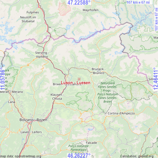
Luson - Luesen GPS coordinates[2]
46° 44' 46.428" North, 11° 45' 39.528" East
| Map corner | latitude | longitude |
|---|---|---|
| Upper-left | 47.22588°, | 11.05786° |
| Center: | 46.74623°, | 11.76098° |
| Lower-right: | 46.26227°, | 12.46411° |
| Map W x H: | 107.1×107.1 km | = 66.5×66.5mi |
| max Lat: | 47.04031° ⇑0.5% North |
| Luson - Luesen: | 46.74623° |
| min Lat: | ⇓99.5% South 35.50142° |
| min Long | Luson - Luesen | max Long |
| 6.69888° | 11.76098° | 18.48682° |
| W 52.6%⇐ | ⇒47.4% E |
Elevation
Elevation of Luson - Luesen is 971 m = 3186 ft, and this is 664.3 m = 2179 ft above average elevation for this country.
| Max E: |
2085 m = 6841 ft | 3.4% |
| Luson - Luesen | 971 m 3186 ft | |
| Avg. | 306.7 m = 1006 ft | |
Min E: |
-4 m = -13 ft | 96.6% |
See also: Italy elevation on elevation.city.
Geographical zone
Luson - Luesen is located in North temperate zone (between Tropic of Cancer and the Arctic Circle). Distance of this North polar circle is 2203.5 km =1369.2 mi to North.| Distance of | km | miles | from Luson - Luesen |
|---|---|---|---|
| North Pole | 4809.4 | 2988.4 | to North |
| Arctic Circle | 2203.5 | 1369.2 | to North |
| Tropic Cancer | 2591.8 | 1610.5 | to South |
| Equator | 5197.7 | 3229.7 | to South |


Nearby cities:
15 places around Luson - Luesen: (largest is in red/bold)
• Bressanone
8.7 km =5.4 mi,  246°
246°
• Casteldarne
8.4 km =5.2 mi,  46°
46°
• Leone-Santa Elisabetta
8.7 km =5.4 mi,  259°
259°
• Naz-Sciaves - Natz-Schabs
7.7 km =4.8 mi,  289°
289°
• Novacella
8.6 km =5.3 mi,  267°
267°
• Rodengo
7.6 km =4.7 mi,  322°
322°
• Rodengo - Rodeneck
6.5 km =4 mi,  304°
304°
• San Sigismondo
7.9 km =4.9 mi,  23°
23°
• Sant'Andrea in Monte
8.2 km =5.1 mi,  230°
230°
• Sciaves
7.6 km =4.7 mi, 288°
• Vandoies - Vintl
8.3 km =5.2 mi,  338°
338°
• Vandoies di Sopra
7.7 km =4.8 mi,  351°
351°
• Vandoies di Sotto
8.3 km =5.2 mi, 338°
• Villa
0.1 km =0.1 mi,  107°
107°
• Villa
6.5 km =4 mi, 304°
Sources, notices
• [Note1] Compared only with cities in Italy existing in our database
• [Src1] Map data: © OpenStreetMap contributors (CC-BY-SA)
• [Src2] Other city data from geonames.org with taken over terms of usage.
• [Src3] Geographical zone / Annual Mean Temperature by Robert A. Rohde @ Wikipedia
