Bressanone geodata
Bressanone (Trentino-Alto Adige) is a seat of a third-order administrative division; located in Italy in Europe/Rome (GMT+2) time zone. With population of 15,868 people, there are 575 cities with bigger population in this country. Compared to other cities in Italy, 99.4% of cities are located further ↓South; 51.2% of cities are located further ←West and 82.5% of cities have lower elevation than Bressanone. Note1


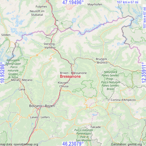
Bressanone GPS coordinates[2]
46° 42' 54.108" North, 11° 39' 21.528" East
| Map corner | latitude | longitude |
|---|---|---|
| Upper-left | 47.19496°, | 10.95286° |
| Center: | 46.71503°, | 11.65598° |
| Lower-right: | 46.23079°, | 12.35911° |
| Map W x H: | 107.2×107.2 km | = 66.6×66.6mi |
| max Lat: | 47.04031° ⇑0.6% North |
| Bressanone: | 46.71503° |
| min Lat: | ⇓99.4% South 35.50142° |
| min Long | Bressanone | max Long |
| 6.69888° | 11.65598° | 18.48682° |
| W 51.2%⇐ | ⇒48.8% E |
Elevation
Elevation of Bressanone is 563 m = 1847 ft, and this is 256.3 m = 841 ft above average elevation for this country.
| Max E: |
2085 m = 6841 ft | 17.5% |
| Bressanone | 563 m 1847 ft | |
| Avg. | 306.7 m = 1006 ft | |
Min E: |
-4 m = -13 ft | 82.5% |
See also: Italy elevation on elevation.city.
Geographical zone
Bressanone is located in North temperate zone (between Tropic of Cancer and the Arctic Circle). Distance of this North polar circle is 2206.9 km =1371.3 mi to North.| Distance of | km | miles | from Bressanone |
|---|---|---|---|
| North Pole | 4812.8 | 2990.5 | to North |
| Arctic Circle | 2206.9 | 1371.3 | to North |
| Tropic Cancer | 2588.3 | 1608.3 | to South |
| Equator | 5194.2 | 3227.5 | to South |


Nearby cities:
15 places around Bressanone: (largest is in red/bold)
• Albes
4.7 km =2.9 mi,  203°
203°
• Fortezza
9 km =5.6 mi,  337°
337°
• Funes - Villnoess
8.2 km =5.1 mi,  168°
168°
• Leone-Santa Elisabetta
1.9 km =1.2 mi, 344°
• Luson - Luesen
8.7 km =5.4 mi,  66°
66°
• Naz-Sciaves - Natz-Schabs
6 km =3.7 mi,  6°
6°
• Novacella
3.2 km =2 mi,  348°
348°
• Rodengo - Rodeneck
7.6 km =4.7 mi,  20°
20°
• San Pietro
8.4 km =5.2 mi, 165°
• Sant'Andrea in Monte
2.4 km =1.5 mi,  136°
136°
• Sciaves
6 km =3.7 mi, 7°
• Varna
3 km =1.9 mi,  332°
332°
• Velturno
7 km =4.3 mi,  220°
220°
• Villa
7.7 km =4.8 mi, 20°
• Villa
8.8 km =5.5 mi, 67°
In other languages:
- In Spanish: Bresanona
- In German: Brixen, Brixen in Südtirol
- In Russian: Брессаноне
Sources, notices
• [Note1] Compared only with cities in Italy existing in our database
• [Src1] Map data: © OpenStreetMap contributors (CC-BY-SA)
• [Src2] Other city data from geonames.org with taken over terms of usage.
• [Src3] Geographical zone / Annual Mean Temperature by Robert A. Rohde @ Wikipedia
