Meleti geodata
Meleti (Lombardy) is a seat of a third-order administrative division; located in Italy in Europe/Rome (GMT+2) time zone. With population of 380 people, there are 10353 cities with bigger population in this country. Compared to other cities in Italy, 63% of cities are located further ↓South; 69.5% of cities are located further →East and 81.7% of cities have higher elevation than Meleti. Note1


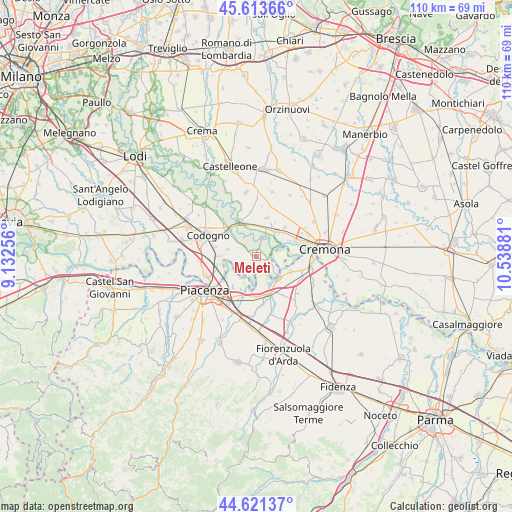
Meleti GPS coordinates[2]
45° 7' 10.812" North, 9° 50' 8.448" East
| Map corner | latitude | longitude |
|---|---|---|
| Upper-left | 45.61366°, | 9.13256° |
| Center: | 45.11967°, | 9.83568° |
| Lower-right: | 44.62137°, | 10.53881° |
| Map W x H: | 110.3×110.3 km | = 68.5×68.5mi |
| max Lat: | 47.04031° ⇑37% North |
| Meleti: | 45.11967° |
| min Lat: | ⇓63% South 35.50142° |
| min Long | Meleti | max Long |
| 6.69888° | 9.83568° | 18.48682° |
| W 30.5%⇐ | ⇒69.5% E |
Elevation
Elevation of Meleti is 43 m = 141 ft, and this is 263.7 m = 865 ft below average elevation for this country.
| Max E: |
2085 m = 6841 ft | 81.7% |
| Avg. | 306.7 m = 1006 ft | |
| Meleti | 43 m = 141 ft | |
Min E: |
-4 m = -13 ft | 18.3% |
See also: Italy elevation on elevation.city.
Geographical zone
Meleti is located in North temperate zone (between Tropic of Cancer and the Arctic Circle). Distance of this North polar circle is 2384.3 km =1481.5 mi to North.| Distance of | km | miles | from Meleti |
|---|---|---|---|
| North Pole | 4990.2 | 3100.8 | to North |
| Arctic Circle | 2384.3 | 1481.5 | to North |
| Tropic Cancer | 2410.9 | 1498.1 | to South |
| Equator | 5016.8 | 3117.3 | to South |


Nearby cities:
15 places around Meleti: (largest is in red/bold)
• Acquanegra Cremonese
6.9 km =4.3 mi,  38°
38°
• Caorso
8.4 km =5.2 mi,  158°
158°
• Caselle Landi
3.7 km =2.3 mi,  238°
238°
• Castelnuovo Bocca d'Adda
2.4 km =1.5 mi,  112°
112°
• Corno Giovine
6.3 km =3.9 mi,  284°
284°
• Cornovecchio
3.4 km =2.1 mi,  303°
303°
• Crotta d'Adda
4.7 km =2.9 mi,  20°
20°
• Fengo
8.2 km =5.1 mi,  29°
29°
• Maccastorna
3.3 km =2.1 mi, 26°
• Maleo
7.7 km =4.8 mi,  312°
312°
• Mortizza
7.9 km =4.9 mi,  232°
232°
• Roggione
7.5 km =4.7 mi,  342°
342°
• San Nazzaro
6.9 km =4.3 mi,  134°
134°
• Santo Stefano Lodigiano
7.9 km =4.9 mi,  269°
269°
• Spinadesco
7.8 km =4.8 mi,  65°
65°
Sources, notices
• [Note1] Compared only with cities in Italy existing in our database
• [Src1] Map data: © OpenStreetMap contributors (CC-BY-SA)
• [Src2] Other city data from geonames.org with taken over terms of usage.
• [Src3] Geographical zone / Annual Mean Temperature by Robert A. Rohde @ Wikipedia
