Montebruno geodata
Montebruno (Liguria) is a seat of a third-order administrative division; located in Italy in Europe/Rome (GMT+2) time zone. With population of 197 people, there are 11150 cities with bigger population in this country. Compared to other cities in Italy, 51.4% of cities are located further ↓South; 77.3% of cities are located further →East and 87.5% of cities have lower elevation than Montebruno. Note1


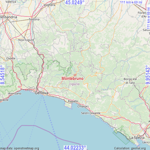
Montebruno GPS coordinates[2]
44° 31' 32.772" North, 9° 14' 53.916" East
| Map corner | latitude | longitude |
|---|---|---|
| Upper-left | 45.0249°, | 8.54518° |
| Center: | 44.52577°, | 9.24831° |
| Lower-right: | 44.02233°, | 9.95143° |
| Map W x H: | 111.5×111.5 km | = 69.3×69.3mi |
| max Lat: | 47.04031° ⇑48.6% North |
| Montebruno: | 44.52577° |
| min Lat: | ⇓51.4% South 35.50142° |
| min Long | Montebruno | max Long |
| 6.69888° | 9.24831° | 18.48682° |
| W 22.7%⇐ | ⇒77.3% E |
Elevation
Elevation of Montebruno is 663 m = 2175 ft, and this is 356.3 m = 1169 ft above average elevation for this country.
| Max E: |
2085 m = 6841 ft | 12.5% |
| Montebruno | 663 m 2175 ft | |
| Avg. | 306.7 m = 1006 ft | |
Min E: |
-4 m = -13 ft | 87.5% |
See also: Italy elevation on elevation.city.
Geographical zone
Montebruno is located in North temperate zone (between Tropic of Cancer and the Arctic Circle). Distance of this Northern Tropic circle is 2344.9 km =1457.1 mi to South.| Distance of | km | miles | from Montebruno |
|---|---|---|---|
| North Pole | 5056.3 | 3141.8 | to North |
| Arctic Circle | 2450.4 | 1522.6 | to North |
| Tropic Cancer | 2344.9 | 1457.1 | to South |
| Equator | 4950.8 | 3076.3 | to South |


Nearby cities:
15 places around Montebruno: (largest is in red/bold)
• Carrega Ligure
11.8 km =7.3 mi,  330°
330°
• Fascia
6.7 km =4.2 mi,  341°
341°
• Favale di Malvaro
8.3 km =5.2 mi,  173°
173°
• Ferrada
12.1 km =7.5 mi,  194°
194°
• Fontanigorda
5 km =3.1 mi,  64°
64°
• Gattorna
11.7 km =7.3 mi,  205°
205°
• Gorreto
9.4 km =5.8 mi,  21°
21°
• Lorsica
10.4 km =6.5 mi, 167°
• Moconesi
12.1 km =7.5 mi, 194°
• Neirone
9.1 km =5.7 mi, 209°
• Propata
6.6 km =4.1 mi,  311°
311°
• Rezzoaglio
11.1 km =6.9 mi,  89°
89°
• Rondanina
4.8 km =3 mi, 330°
• Rovegno
6.2 km =3.9 mi, 23°
• Torriglia
7.2 km =4.5 mi,  262°
262°
Sources, notices
• [Note1] Compared only with cities in Italy existing in our database
• [Src1] Map data: © OpenStreetMap contributors (CC-BY-SA)
• [Src2] Other city data from geonames.org with taken over terms of usage.
• [Src3] Geographical zone / Annual Mean Temperature by Robert A. Rohde @ Wikipedia
