Fascia geodata
Fascia (Liguria) is a seat of a third-order administrative division; located in Italy in Europe/Rome (GMT+2) time zone. With population of 21 people, there are 11675 cities with bigger population in this country. Compared to other cities in Italy, 52.2% of cities are located further ↓South; 77.7% of cities are located further →East and 98.1% of cities have lower elevation than Fascia. Note1


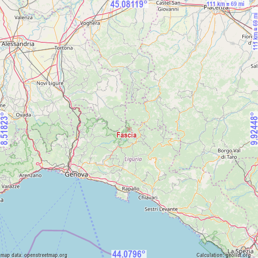
Fascia GPS coordinates[2]
44° 34' 57.18" North, 9° 13' 16.896" East
| Map corner | latitude | longitude |
|---|---|---|
| Upper-left | 45.08119°, | 8.51823° |
| Center: | 44.58255°, | 9.22136° |
| Lower-right: | 44.0796°, | 9.92448° |
| Map W x H: | 111.4×111.4 km | = 69.2×69.2mi |
| max Lat: | 47.04031° ⇑47.8% North |
| Fascia: | 44.58255° |
| min Lat: | ⇓52.2% South 35.50142° |
| min Long | Fascia | max Long |
| 6.69888° | 9.22136° | 18.48682° |
| W 22.3%⇐ | ⇒77.7% E |
Elevation
Elevation of Fascia is 1113 m = 3652 ft, and this is 806.3 m = 2645 ft above average elevation for this country.
| Max E: |
2085 m = 6841 ft | 1.9% |
| Fascia | 1113 m 3652 ft | |
| Avg. | 306.7 m = 1006 ft | |
Min E: |
-4 m = -13 ft | 98.1% |
See also: Italy elevation on elevation.city.
Geographical zone
Fascia is located in North temperate zone (between Tropic of Cancer and the Arctic Circle). Distance of this Northern Tropic circle is 2351.2 km =1461 mi to South.| Distance of | km | miles | from Fascia |
|---|---|---|---|
| North Pole | 5049.9 | 3137.9 | to North |
| Arctic Circle | 2444.1 | 1518.7 | to North |
| Tropic Cancer | 2351.2 | 1461 | to South |
| Equator | 4957.1 | 3080.2 | to South |


Nearby cities:
15 places around Fascia: (largest is in red/bold)
• Cabella Ligure
14.3 km =8.9 mi,  316°
316°
• Carrega Ligure
5.4 km =3.4 mi, 318°
• Fontanigorda
7.8 km =4.8 mi,  121°
121°
• Gorreto
6.1 km =3.8 mi,  65°
65°
• Molino Vecchio-Scapitola-Baio
12.5 km =7.8 mi,  256°
256°
• Mongiardino Ligure
13.7 km =8.5 mi,  294°
294°
• Montebruno
6.7 km =4.2 mi,  161°
161°
• Neirone
14.4 km =8.9 mi,  189°
189°
• Ottone
9.9 km =6.2 mi,  62°
62°
• Propata
3.4 km =2.1 mi,  235°
235°
• Rezzoaglio
14.6 km =9.1 mi, 115°
• Rondanina
2.2 km =1.4 mi, 186°
• Rovegno
4.6 km =2.9 mi,  98°
98°
• Torriglia
8.8 km =5.5 mi,  214°
214°
• Zerba
10.6 km =6.6 mi,  29°
29°
Sources, notices
• [Note1] Compared only with cities in Italy existing in our database
• [Src1] Map data: © OpenStreetMap contributors (CC-BY-SA)
• [Src2] Other city data from geonames.org with taken over terms of usage.
• [Src3] Geographical zone / Annual Mean Temperature by Robert A. Rohde @ Wikipedia
