Rovegno geodata
Rovegno (Liguria) is a seat of a third-order administrative division; located in Italy in Europe/Rome (GMT+2) time zone. With population of 98 people, there are 11449 cities with bigger population in this country. Compared to other cities in Italy, 52.1% of cities are located further ↓South; 76.7% of cities are located further →East and 87.6% of cities have lower elevation than Rovegno. Note1


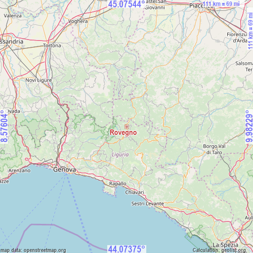
Rovegno GPS coordinates[2]
44° 34' 36.3" North, 9° 16' 45.012" East
| Map corner | latitude | longitude |
|---|---|---|
| Upper-left | 45.07544°, | 8.57604° |
| Center: | 44.57675°, | 9.27917° |
| Lower-right: | 44.07375°, | 9.98229° |
| Map W x H: | 111.4×111.4 km | = 69.2×69.2mi |
| max Lat: | 47.04031° ⇑47.9% North |
| Rovegno: | 44.57675° |
| min Lat: | ⇓52.1% South 35.50142° |
| min Long | Rovegno | max Long |
| 6.69888° | 9.27917° | 18.48682° |
| W 23.3%⇐ | ⇒76.7% E |
Elevation
Elevation of Rovegno is 665 m = 2182 ft, and this is 358.3 m = 1176 ft above average elevation for this country.
| Max E: |
2085 m = 6841 ft | 12.4% |
| Rovegno | 665 m 2182 ft | |
| Avg. | 306.7 m = 1006 ft | |
Min E: |
-4 m = -13 ft | 87.6% |
See also: Italy elevation on elevation.city.
Geographical zone
Rovegno is located in North temperate zone (between Tropic of Cancer and the Arctic Circle). Distance of this Northern Tropic circle is 2350.6 km =1460.6 mi to South.| Distance of | km | miles | from Rovegno |
|---|---|---|---|
| North Pole | 5050.6 | 3138.3 | to North |
| Arctic Circle | 2444.7 | 1519.1 | to North |
| Tropic Cancer | 2350.6 | 1460.6 | to South |
| Equator | 4956.5 | 3079.8 | to South |


Nearby cities:
15 places around Rovegno: (largest is in red/bold)
• Carrega Ligure
9.4 km =5.8 mi,  299°
299°
• Cerignale
12.6 km =7.8 mi,  26°
26°
• Fascia
4.6 km =2.9 mi,  278°
278°
• Favale di Malvaro
14 km =8.7 mi,  186°
186°
• Fontanigorda
4.1 km =2.5 mi,  149°
149°
• Gorreto
3.3 km =2.1 mi,  17°
17°
• Montebruno
6.2 km =3.9 mi,  203°
203°
• Neirone
15.2 km =9.4 mi,  207°
207°
• Ottone
6.7 km =4.2 mi,  39°
39°
• Propata
7.5 km =4.7 mi,  259°
259°
• Rezzoaglio
10.3 km =6.4 mi,  123°
123°
• Rondanina
5.1 km =3.2 mi,  252°
252°
• Santo Stefano d'Aveto
14.2 km =8.8 mi,  103°
103°
• Torriglia
11.6 km =7.2 mi,  235°
235°
• Zerba
9.9 km =6.2 mi,  4°
4°
Sources, notices
• [Note1] Compared only with cities in Italy existing in our database
• [Src1] Map data: © OpenStreetMap contributors (CC-BY-SA)
• [Src2] Other city data from geonames.org with taken over terms of usage.
• [Src3] Geographical zone / Annual Mean Temperature by Robert A. Rohde @ Wikipedia
