Carrega Ligure geodata
Carrega Ligure (Piedmont) is a seat of a third-order administrative division; located in Italy in Europe/Rome (GMT+2) time zone. With population of 22 people, there are 11670 cities with bigger population in this country. Compared to other cities in Italy, 52.8% of cities are located further ↓South; 78.4% of cities are located further →East and 96.1% of cities have lower elevation than Carrega Ligure. Note1
Administrative division(s):
- Level 1: Piedmont
- Level 2: Provincia di Alessandria
- Level 3: Carrega Ligure


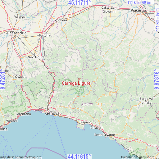
Carrega Ligure GPS coordinates[2]
44° 37' 7.644" North, 9° 10' 32.304" East
| Map corner | latitude | longitude |
|---|---|---|
| Upper-left | 45.11711°, | 8.47251° |
| Center: | 44.61879°, | 9.17564° |
| Lower-right: | 44.11615°, | 9.87876° |
| Map W x H: | 111.3×111.3 km | = 69.2×69.2mi |
| max Lat: | 47.04031° ⇑47.2% North |
| Carrega Ligure: | 44.61879° |
| min Lat: | ⇓52.8% South 35.50142° |
| min Long | Carrega Ligure | max Long |
| 6.69888° | 9.17564° | 18.48682° |
| W 21.6%⇐ | ⇒78.4% E |
Elevation
Elevation of Carrega Ligure is 942 m = 3091 ft, and this is 635.3 m = 2084 ft above average elevation for this country.
| Max E: |
2085 m = 6841 ft | 3.9% |
| Carrega Ligure | 942 m 3091 ft | |
| Avg. | 306.7 m = 1006 ft | |
Min E: |
-4 m = -13 ft | 96.1% |
See also: Italy elevation on elevation.city.
Geographical zone
Carrega Ligure is located in North temperate zone (between Tropic of Cancer and the Arctic Circle). Distance of this Northern Tropic circle is 2355.2 km =1463.5 mi to South.| Distance of | km | miles | from Carrega Ligure |
|---|---|---|---|
| North Pole | 5045.9 | 3135.4 | to North |
| Arctic Circle | 2440 | 1516.1 | to North |
| Tropic Cancer | 2355.2 | 1463.5 | to South |
| Equator | 4961.1 | 3082.7 | to South |


Nearby cities:
15 places around Carrega Ligure: (largest is in red/bold)
• Albera Ligure
12.6 km =7.8 mi,  317°
317°
• Cabella Ligure
8.9 km =5.5 mi,  314°
314°
• Crocefieschi
12.8 km =8 mi,  250°
250°
• Fascia
5.4 km =3.4 mi,  138°
138°
• Gorreto
9.3 km =5.8 mi,  99°
99°
• Molino Vecchio-Scapitola-Baio
11 km =6.8 mi,  230°
230°
• Mongiardino Ligure
9 km =5.6 mi,  281°
281°
• Montebruno
11.8 km =7.3 mi,  150°
150°
• Ottone
12.4 km =7.7 mi,  87°
87°
• Propata
6 km =3.7 mi,  172°
172°
• Rondanina
7 km =4.3 mi, 151°
• Rovegno
9.4 km =5.8 mi,  119°
119°
• Torriglia
11.3 km =7 mi,  187°
187°
• Vobbia
11 km =6.8 mi,  259°
259°
• Zerba
10.3 km =6.4 mi,  59°
59°
Sources, notices
• [Note1] Compared only with cities in Italy existing in our database
• [Src1] Map data: © OpenStreetMap contributors (CC-BY-SA)
• [Src2] Other city data from geonames.org with taken over terms of usage.
• [Src3] Geographical zone / Annual Mean Temperature by Robert A. Rohde @ Wikipedia
