Fontanigorda geodata
Fontanigorda (Liguria) is a seat of a third-order administrative division; located in Italy in Europe/Rome (GMT+2) time zone. With population of 182 people, there are 11190 cities with bigger population in this country. Compared to other cities in Italy, 51.6% of cities are located further ↓South; 76.3% of cities are located further →East and 93.3% of cities have lower elevation than Fontanigorda. Note1


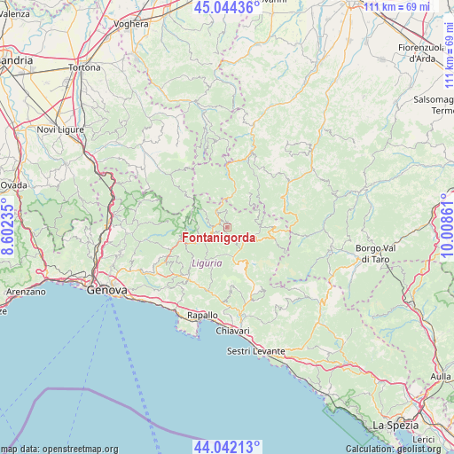
Fontanigorda GPS coordinates[2]
44° 32' 43.44" North, 9° 18' 19.728" East
| Map corner | latitude | longitude |
|---|---|---|
| Upper-left | 45.04436°, | 8.60235° |
| Center: | 44.5454°, | 9.30548° |
| Lower-right: | 44.04213°, | 10.00861° |
| Map W x H: | 111.4×111.4 km | = 69.2×69.2mi |
| max Lat: | 47.04031° ⇑48.4% North |
| Fontanigorda: | 44.5454° |
| min Lat: | ⇓51.6% South 35.50142° |
| min Long | Fontanigorda | max Long |
| 6.69888° | 9.30548° | 18.48682° |
| W 23.7%⇐ | ⇒76.3% E |
Elevation
Elevation of Fontanigorda is 809 m = 2654 ft, and this is 502.3 m = 1648 ft above average elevation for this country.
| Max E: |
2085 m = 6841 ft | 6.7% |
| Fontanigorda | 809 m 2654 ft | |
| Avg. | 306.7 m = 1006 ft | |
Min E: |
-4 m = -13 ft | 93.3% |
See also: Italy elevation on elevation.city.
Geographical zone
Fontanigorda is located in North temperate zone (between Tropic of Cancer and the Arctic Circle). Distance of this Northern Tropic circle is 2347.1 km =1458.4 mi to South.| Distance of | km | miles | from Fontanigorda |
|---|---|---|---|
| North Pole | 5054.1 | 3140.5 | to North |
| Arctic Circle | 2448.2 | 1521.2 | to North |
| Tropic Cancer | 2347.1 | 1458.4 | to South |
| Equator | 4953 | 3077.7 | to South |


Nearby cities:
15 places around Fontanigorda: (largest is in red/bold)
• Carrega Ligure
13.1 km =8.1 mi,  308°
308°
• Fascia
7.8 km =4.8 mi,  301°
301°
• Favale di Malvaro
11 km =6.8 mi,  199°
199°
• Gorreto
6.7 km =4.2 mi,  350°
350°
• Lorsica
12.6 km =7.8 mi,  190°
190°
• Montebruno
5 km =3.1 mi,  244°
244°
• Neirone
13.5 km =8.4 mi,  221°
221°
• Ottone
8.9 km =5.5 mi,  13°
13°
• Propata
9.7 km =6 mi,  282°
282°
• Rezzoaglio
6.9 km =4.3 mi,  107°
107°
• Rondanina
7.2 km =4.5 mi,  285°
285°
• Rovegno
4.1 km =2.5 mi,  329°
329°
• Santo Stefano d'Aveto
11.7 km =7.3 mi,  89°
89°
• Torriglia
12.1 km =7.5 mi,  255°
255°
• Zerba
13.4 km =8.3 mi, 354°
Sources, notices
• [Note1] Compared only with cities in Italy existing in our database
• [Src1] Map data: © OpenStreetMap contributors (CC-BY-SA)
• [Src2] Other city data from geonames.org with taken over terms of usage.
• [Src3] Geographical zone / Annual Mean Temperature by Robert A. Rohde @ Wikipedia
