Mezzolombardo geodata
Mezzolombardo (Trentino-Alto Adige) is a seat of a third-order administrative division; located in Italy in Europe/Rome (GMT+2) time zone. With population of 6,754 people, there are 1455 cities with bigger population in this country. Compared to other cities in Italy, 96.1% of cities are located further ↓South; 55.9% of cities are located further →East and 52.5% of cities have higher elevation than Mezzolombardo. Note1
Administrative division(s):
- Level 1: Trentino-Alto Adige
- Level 2: Provincia autonoma di Trento
- Level 3: Mezzolombardo


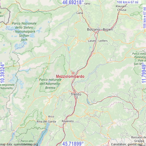
Mezzolombardo GPS coordinates[2]
46° 12' 27.864" North, 11° 5' 46.896" East
| Map corner | latitude | longitude |
|---|---|---|
| Upper-left | 46.69218°, | 10.39324° |
| Center: | 46.20774°, | 11.09636° |
| Lower-right: | 45.71899°, | 11.79949° |
| Map W x H: | 108.2×108.2 km | = 67.2×67.2mi |
| max Lat: | 47.04031° ⇑3.9% North |
| Mezzolombardo: | 46.20774° |
| min Lat: | ⇓96.1% South 35.50142° |
| min Long | Mezzolombardo | max Long |
| 6.69888° | 11.09636° | 18.48682° |
| W 44.1%⇐ | ⇒55.9% E |
Elevation
Elevation of Mezzolombardo is 219 m = 719 ft, and this is 87.7 m = 288 ft below average elevation for this country.
| Max E: |
2085 m = 6841 ft | 52.5% |
| Avg. | 306.7 m = 1006 ft | |
| Mezzolombardo | 219 m = 719 ft | |
Min E: |
-4 m = -13 ft | 47.5% |
See also: Italy elevation on elevation.city.
Geographical zone
Mezzolombardo is located in North temperate zone (between Tropic of Cancer and the Arctic Circle). Distance of this North polar circle is 2263.4 km =1406.4 mi to North.| Distance of | km | miles | from Mezzolombardo |
|---|---|---|---|
| North Pole | 4869.2 | 3025.6 | to North |
| Arctic Circle | 2263.4 | 1406.4 | to North |
| Tropic Cancer | 2531.9 | 1573.2 | to South |
| Equator | 5137.8 | 3192.5 | to South |


Nearby cities:
15 places around Mezzolombardo: (largest is in red/bold)
• Campodenno
7.4 km =4.6 mi,  318°
318°
• Cavedago
5.5 km =3.4 mi,  242°
242°
• Faedo
5.3 km =3.3 mi,  108°
108°
• Fai della Paganella
3.9 km =2.4 mi,  212°
212°
• Giovo
7.2 km =4.5 mi,  143°
143°
• Mezzocorona
2.1 km =1.3 mi,  77°
77°
• Nave San Rocco
4.5 km =2.8 mi,  171°
171°
• Palù
6.5 km =4 mi,  147°
147°
• Pressano
6.2 km =3.9 mi, 173°
• San Michele All'Adige
3.4 km =2.1 mi,  126°
126°
• Spormaggiore
3.9 km =2.4 mi,  287°
287°
• Sporminore
6.1 km =3.8 mi,  302°
302°
• Verla
7.1 km =4.4 mi, 141°
• Vigo di Ton
6.4 km =4 mi,  354°
354°
• Zambana
6.2 km =3.9 mi,  180°
180°
Sources, notices
• [Note1] Compared only with cities in Italy existing in our database
• [Src1] Map data: © OpenStreetMap contributors (CC-BY-SA)
• [Src2] Other city data from geonames.org with taken over terms of usage.
• [Src3] Geographical zone / Annual Mean Temperature by Robert A. Rohde @ Wikipedia
