Sporminore geodata
Sporminore (Trentino-Alto Adige) is a seat of a third-order administrative division; located in Italy in Europe/Rome (GMT+2) time zone. With population of 639 people, there are 8711 cities with bigger population in this country. Compared to other cities in Italy, 96.3% of cities are located further ↓South; 56.9% of cities are located further →East and 81.4% of cities have lower elevation than Sporminore. Note1
Administrative division(s):
- Level 1: Trentino-Alto Adige
- Level 2: Provincia autonoma di Trento
- Level 3: Sporminore


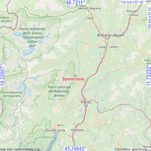
Sporminore GPS coordinates[2]
46° 14' 12.912" North, 11° 1' 45.084" East
| Map corner | latitude | longitude |
|---|---|---|
| Upper-left | 46.7211°, | 10.32607° |
| Center: | 46.23692°, | 11.02919° |
| Lower-right: | 45.74843°, | 11.73232° |
| Map W x H: | 108.2×108.1 km | = 67.2×67.2mi |
| max Lat: | 47.04031° ⇑3.7% North |
| Sporminore: | 46.23692° |
| min Lat: | ⇓96.3% South 35.50142° |
| min Long | Sporminore | max Long |
| 6.69888° | 11.02919° | 18.48682° |
| W 43.1%⇐ | ⇒56.9% E |
Elevation
Elevation of Sporminore is 545 m = 1788 ft, and this is 238.3 m = 782 ft above average elevation for this country.
| Max E: |
2085 m = 6841 ft | 18.6% |
| Sporminore | 545 m 1788 ft | |
| Avg. | 306.7 m = 1006 ft | |
Min E: |
-4 m = -13 ft | 81.4% |
See also: Italy elevation on elevation.city.
Geographical zone
Sporminore is located in North temperate zone (between Tropic of Cancer and the Arctic Circle). Distance of this North polar circle is 2260.1 km =1404.4 mi to North.| Distance of | km | miles | from Sporminore |
|---|---|---|---|
| North Pole | 4866 | 3023.6 | to North |
| Arctic Circle | 2260.1 | 1404.4 | to North |
| Tropic Cancer | 2535.1 | 1575.2 | to South |
| Equator | 5141.1 | 3194.5 | to South |


Nearby cities:
15 places around Sporminore: (largest is in red/bold)
• Andalo
8.1 km =5 mi,  193°
193°
• Campodenno
2.4 km =1.5 mi,  7°
7°
• Cavedago
5.8 km =3.6 mi,  177°
177°
• Cunevo
5.5 km =3.4 mi,  4°
4°
• Denno
4.4 km =2.7 mi,  20°
20°
• Fai della Paganella
7.2 km =4.5 mi,  154°
154°
• Flavon
6.8 km =4.2 mi, 0°
• Mezzocorona
7.7 km =4.8 mi,  111°
111°
• Mezzolombardo
6.1 km =3.8 mi,  122°
122°
• Nanno
8.8 km =5.5 mi, 9°
• San Michele All'Adige
9.5 km =5.9 mi, 123°
• Segno
8.4 km =5.2 mi, 24°
• Spormaggiore
2.5 km =1.6 mi,  144°
144°
• Terres
8.1 km =5 mi,  356°
356°
• Vigo di Ton
5.5 km =3.4 mi,  55°
55°
Sources, notices
• [Note1] Compared only with cities in Italy existing in our database
• [Src1] Map data: © OpenStreetMap contributors (CC-BY-SA)
• [Src2] Other city data from geonames.org with taken over terms of usage.
• [Src3] Geographical zone / Annual Mean Temperature by Robert A. Rohde @ Wikipedia
