Fai della Paganella geodata
Fai della Paganella (Trentino-Alto Adige) is a seat of a third-order administrative division; located in Italy in Europe/Rome (GMT+2) time zone. With population of 884 people, there are 7246 cities with bigger population in this country. Compared to other cities in Italy, 95.7% of cities are located further ↓South; 56.3% of cities are located further →East and 96.6% of cities have lower elevation than Fai della Paganella. Note1
Administrative division(s):
- Level 1: Trentino-Alto Adige
- Level 2: Provincia autonoma di Trento
- Level 3: Fai della Paganella


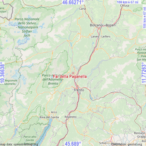
Fai della Paganella GPS coordinates[2]
46° 10' 40.836" North, 11° 4' 10.2" East
| Map corner | latitude | longitude |
|---|---|---|
| Upper-left | 46.66271°, | 10.36638° |
| Center: | 46.17801°, | 11.0695° |
| Lower-right: | 45.689°, | 11.77263° |
| Map W x H: | 108.3×108.3 km | = 67.3×67.3mi |
| max Lat: | 47.04031° ⇑4.3% North |
| Fai della Paganella: | 46.17801° |
| min Lat: | ⇓95.7% South 35.50142° |
| min Long | Fai della Pagan | max Long |
| 6.69888° | 11.0695° | 18.48682° |
| W 43.7%⇐ | ⇒56.3% E |
Elevation
Elevation of Fai della Paganella is 975 m = 3199 ft, and this is 668.3 m = 2193 ft above average elevation for this country.
| Max E: |
2085 m = 6841 ft | 3.4% |
| Fai della Paganella | 975 m 3199 ft | |
| Avg. | 306.7 m = 1006 ft | |
Min E: |
-4 m = -13 ft | 96.6% |
See also: Italy elevation on elevation.city.
Geographical zone
Fai della Paganella is located in North temperate zone (between Tropic of Cancer and the Arctic Circle). Distance of this North polar circle is 2266.7 km =1408.5 mi to North.| Distance of | km | miles | from Fai della Paganella |
|---|---|---|---|
| North Pole | 4872.5 | 3027.6 | to North |
| Arctic Circle | 2266.7 | 1408.5 | to North |
| Tropic Cancer | 2528.6 | 1571.2 | to South |
| Equator | 5134.5 | 3190.4 | to South |


Nearby cities:
15 places around Fai della Paganella: (largest is in red/bold)
• Andalo
5.2 km =3.2 mi,  255°
255°
• Cavedago
2.9 km =1.8 mi,  285°
285°
• Giovo
6.9 km =4.3 mi,  111°
111°
• Lavis
5.1 km =3.2 mi,  143°
143°
• Meano
7 km =4.3 mi,  148°
148°
• Mezzocorona
5.5 km =3.4 mi,  47°
47°
• Mezzolombardo
3.9 km =2.4 mi,  32°
32°
• Nave San Rocco
3 km =1.9 mi, 112°
• Palù
6 km =3.7 mi, 111°
• Pressano
4 km =2.5 mi, 135°
• San Michele All'Adige
5 km =3.1 mi,  74°
74°
• Spormaggiore
4.8 km =3 mi,  339°
339°
• Verla
6.8 km =4.2 mi, 109°
• Vigo Meano
7 km =4.3 mi,  134°
134°
• Zambana
3.6 km =2.2 mi, 144°
Sources, notices
• [Note1] Compared only with cities in Italy existing in our database
• [Src1] Map data: © OpenStreetMap contributors (CC-BY-SA)
• [Src2] Other city data from geonames.org with taken over terms of usage.
• [Src3] Geographical zone / Annual Mean Temperature by Robert A. Rohde @ Wikipedia
