Mesagne geodata
Mesagne (Apulia) is a seat of a third-order administrative division; located in Italy in Europe/Rome (GMT+2) time zone. With population of 26,497 people, there are 306 cities with bigger population in this country. Compared to other cities in Italy, 83.8% of cities are located further ↑North; 98.8% of cities are located further ←West and 75.6% of cities have higher elevation than Mesagne. Note1


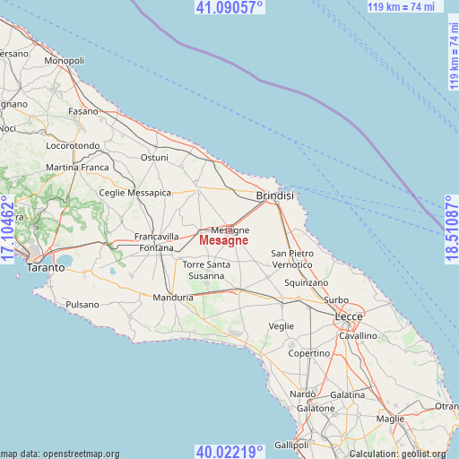
Mesagne GPS coordinates[2]
40° 33' 30.636" North, 17° 48' 27.864" East
| Map corner | latitude | longitude |
|---|---|---|
| Upper-left | 41.09057°, | 17.10462° |
| Center: | 40.55851°, | 17.80774° |
| Lower-right: | 40.02219°, | 18.51087° |
| Map W x H: | 118.8×118.8 km | = 73.8×73.8mi |
| max Lat: | 47.04031° ⇑83.8% North |
| Mesagne: | 40.55851° |
| min Lat: | ⇓16.2% South 35.50142° |
| min Long | Mesagne | max Long |
| 6.69888° | 17.80774° | 18.48682° |
| W 98.8%⇐ | ⇒1.2% E |
Elevation
Elevation of Mesagne is 71 m = 233 ft, and this is 235.7 m = 773 ft below average elevation for this country.
| Max E: |
2085 m = 6841 ft | 75.6% |
| Avg. | 306.7 m = 1006 ft | |
| Mesagne | 71 m = 233 ft | |
Min E: |
-4 m = -13 ft | 24.4% |
See also: Italy elevation on elevation.city.
Geographical zone
Mesagne is located in North temperate zone (between Tropic of Cancer and the Arctic Circle). Distance of this Northern Tropic circle is 1903.8 km =1183 mi to South.| Distance of | km | miles | from Mesagne |
|---|---|---|---|
| North Pole | 5497.4 | 3415.9 | to North |
| Arctic Circle | 2891.5 | 1796.7 | to North |
| Tropic Cancer | 1903.8 | 1183 | to South |
| Equator | 4509.7 | 2802.2 | to South |


Nearby cities:
15 places around Mesagne: (largest is in red/bold)
• Betlemme
17 km =10.6 mi,  41°
41°
• Brindisi
13.6 km =8.5 mi,  52°
52°
• Cellino San Marco
16.4 km =10.2 mi,  126°
126°
• Erchie
14.9 km =9.3 mi,  203°
203°
• La Rosa
13.3 km =8.3 mi,  66°
66°
• Latiano
7.6 km =4.7 mi,  263°
263°
• Materdomini
16.8 km =10.4 mi, 49°
• Oria
15.4 km =9.6 mi,  244°
244°
• San Donaci
15.6 km =9.7 mi,  141°
141°
• San Michele Salentino
16.9 km =10.5 mi,  298°
298°
• San Pancrazio Salentino
15.8 km =9.8 mi,  171°
171°
• San Pietro Vernotico
17.8 km =11.1 mi,  115°
115°
• San Vito dei Normanni
13.8 km =8.6 mi,  322°
322°
• Torre Santa Susanna
11.7 km =7.3 mi,  210°
210°
• Tuturano
11.9 km =7.4 mi,  97°
97°
Sources, notices
• [Note1] Compared only with cities in Italy existing in our database
• [Src1] Map data: © OpenStreetMap contributors (CC-BY-SA)
• [Src2] Other city data from geonames.org with taken over terms of usage.
• [Src3] Geographical zone / Annual Mean Temperature by Robert A. Rohde @ Wikipedia
