Betlemme geodata
Betlemme (Apulia) is a populated place; located in Italy in Europe/Rome (GMT+2) time zone. With population of 562 people, there are 9332 cities with bigger population in this country. Compared to other cities in Italy, 82.7% of cities are located further ↑North; 98.8% of cities are located further ←West and 99.4% of cities have higher elevation than Betlemme. Note1


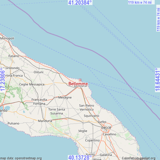
Betlemme GPS coordinates[2]
40° 40' 21.684" North, 17° 56' 28.248" East
| Map corner | latitude | longitude |
|---|---|---|
| Upper-left | 41.20384°, | 17.23806° |
| Center: | 40.67269°, | 17.94118° |
| Lower-right: | 40.13728°, | 18.64431° |
| Map W x H: | 118.6×118.6 km | = 73.7×73.7mi |
| max Lat: | 47.04031° ⇑82.7% North |
| Betlemme: | 40.67269° |
| min Lat: | ⇓17.3% South 35.50142° |
| min Long | Betlemme | max Long |
| 6.69888° | 17.94118° | 18.48682° |
| W 98.8%⇐ | ⇒1.2% E |
Elevation
Elevation of Betlemme is 1 m = 3 ft, and this is 305.7 m = 1003 ft below average elevation for this country.
| Max E: |
2085 m = 6841 ft | 99.4% |
| Avg. | 306.7 m = 1006 ft | |
| Betlemme | 1 m = 3 ft | |
Min E: |
-4 m = -13 ft | 0.6% |
See also: Italy elevation on elevation.city.
Geographical zone
Betlemme is located in North temperate zone (between Tropic of Cancer and the Arctic Circle). Distance of this Northern Tropic circle is 1916.5 km =1190.9 mi to South.| Distance of | km | miles | from Betlemme |
|---|---|---|---|
| North Pole | 5484.7 | 3408 | to North |
| Arctic Circle | 2878.8 | 1788.8 | to North |
| Tropic Cancer | 1916.5 | 1190.9 | to South |
| Equator | 4522.4 | 2810.1 | to South |


Nearby cities:
15 places around Betlemme: (largest is in red/bold)
• Brindisi
4.5 km =2.8 mi,  185°
185°
• Carovigno
24.1 km =15 mi,  278°
278°
• Cellino San Marco
22.5 km =14 mi,  175°
175°
• La Rosa
7.4 km =4.6 mi,  172°
172°
• Latiano
23.2 km =14.4 mi,  234°
234°
• Materdomini
2.4 km =1.5 mi,  140°
140°
• Mesagne
17 km =10.6 mi,  221°
221°
• San Donaci
25 km =15.5 mi, 183°
• San Michele Salentino
26.4 km =16.4 mi,  260°
260°
• San Pietro Vernotico
21 km =13 mi, 166°
• San Vito dei Normanni
19.7 km =12.2 mi, 264°
• Squinzano
27.7 km =17.2 mi,  162°
162°
• Torchiarolo
23 km =14.3 mi, 156°
• Torre Santa Susanna
28.5 km =17.7 mi, 216°
• Tuturano
14.2 km =8.8 mi, 177°
Sources, notices
• [Note1] Compared only with cities in Italy existing in our database
• [Src1] Map data: © OpenStreetMap contributors (CC-BY-SA)
• [Src2] Other city data from geonames.org with taken over terms of usage.
• [Src3] Geographical zone / Annual Mean Temperature by Robert A. Rohde @ Wikipedia
