Dugenta geodata
Dugenta (Campania) is a seat of a third-order administrative division; located in Italy in Europe/Rome (GMT+2) time zone. With population of 1,201 people, there are 5953 cities with bigger population in this country. Compared to other cities in Italy, 77.3% of cities are located further ↑North; 82.3% of cities are located further ←West and 78.5% of cities have higher elevation than Dugenta. Note1


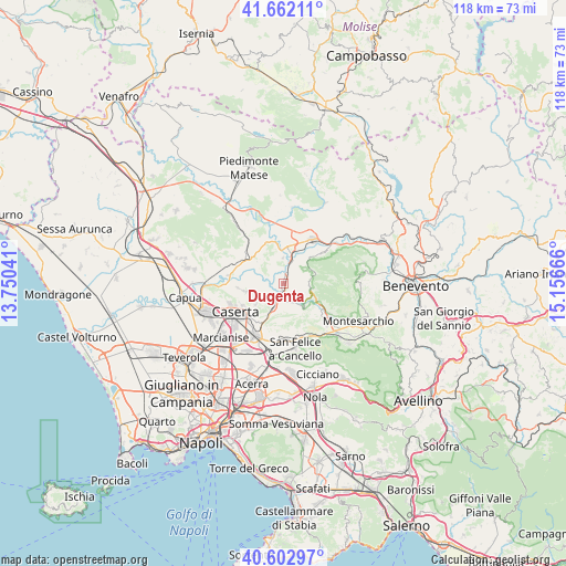
Dugenta GPS coordinates[2]
41° 8' 4.848" North, 14° 27' 12.708" East
| Map corner | latitude | longitude |
|---|---|---|
| Upper-left | 41.66211°, | 13.75041° |
| Center: | 41.13468°, | 14.45353° |
| Lower-right: | 40.60297°, | 15.15666° |
| Map W x H: | 117.8×117.8 km | = 73.2×73.2mi |
| max Lat: | 47.04031° ⇑77.3% North |
| Dugenta: | 41.13468° |
| min Lat: | ⇓22.7% South 35.50142° |
| min Long | Dugenta | max Long |
| 6.69888° | 14.45353° | 18.48682° |
| W 82.3%⇐ | ⇒17.7% E |
Elevation
Elevation of Dugenta is 57 m = 187 ft, and this is 249.7 m = 819 ft below average elevation for this country.
| Max E: |
2085 m = 6841 ft | 78.5% |
| Avg. | 306.7 m = 1006 ft | |
| Dugenta | 57 m = 187 ft | |
Min E: |
-4 m = -13 ft | 21.5% |
See also: Italy elevation on elevation.city.
Geographical zone
Dugenta is located in North temperate zone (between Tropic of Cancer and the Arctic Circle). Distance of this Northern Tropic circle is 1967.8 km =1222.7 mi to South.| Distance of | km | miles | from Dugenta |
|---|---|---|---|
| North Pole | 5433.3 | 3376.1 | to North |
| Arctic Circle | 2827.4 | 1756.9 | to North |
| Tropic Cancer | 1967.8 | 1222.7 | to South |
| Equator | 4573.7 | 2842 | to South |


Nearby cities:
15 places around Dugenta: (largest is in red/bold)
• Amorosi
7.6 km =4.7 mi,  7°
7°
• Annunziata
7.6 km =4.7 mi,  258°
258°
• Bagnoli
5.9 km =3.7 mi,  190°
190°
• Casola
7.5 km =4.7 mi,  233°
233°
• Castel Campagnano
5.3 km =3.3 mi,  359°
359°
• Castel Morrone
8.4 km =5.2 mi, 259°
• Durazzano
8 km =5 mi,  182°
182°
• Frasso Telesino
6.7 km =4.2 mi,  68°
68°
• Giardoni
2.7 km =1.7 mi, 229°
• Limatola
5 km =3.1 mi,  276°
276°
• Melizzano
5.3 km =3.3 mi,  55°
55°
• Ruviano
9.2 km =5.7 mi,  336°
336°
• San Giovanni e Paolo
7.2 km =4.5 mi,  309°
309°
• Sant'Agata de'Goti
6.2 km =3.9 mi,  143°
143°
• Valle di Maddaloni
6.8 km =4.2 mi,  205°
205°
Sources, notices
• [Note1] Compared only with cities in Italy existing in our database
• [Src1] Map data: © OpenStreetMap contributors (CC-BY-SA)
• [Src2] Other city data from geonames.org with taken over terms of usage.
• [Src3] Geographical zone / Annual Mean Temperature by Robert A. Rohde @ Wikipedia
