Budrio geodata
Budrio (Emilia-Romagna) is a seat of a third-order administrative division; located in Italy in Europe/Rome (GMT+2) time zone. With population of 8,941 people, there are 1061 cities with bigger population in this country. Compared to other cities in Italy, 51.5% of cities are located further ↓South; 50.1% of cities are located further →East and 86.1% of cities have higher elevation than Budrio. Note1


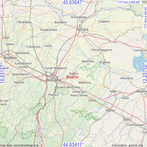
Budrio GPS coordinates[2]
44° 32' 14.82" North, 11° 32' 3.804" East
| Map corner | latitude | longitude |
|---|---|---|
| Upper-left | 45.03647°, | 10.83127° |
| Center: | 44.53745°, | 11.53439° |
| Lower-right: | 44.03411°, | 12.23752° |
| Map W x H: | 111.5×111.5 km | = 69.3×69.3mi |
| max Lat: | 47.04031° ⇑48.5% North |
| Budrio: | 44.53745° |
| min Lat: | ⇓51.5% South 35.50142° |
| min Long | Budrio | max Long |
| 6.69888° | 11.53439° | 18.48682° |
| W 49.9%⇐ | ⇒50.1% E |
Elevation
Elevation of Budrio is 28 m = 92 ft, and this is 278.7 m = 914 ft below average elevation for this country.
| Max E: |
2085 m = 6841 ft | 86.1% |
| Avg. | 306.7 m = 1006 ft | |
| Budrio | 28 m = 92 ft | |
Min E: |
-4 m = -13 ft | 13.9% |
See also: Italy elevation on elevation.city.
Geographical zone
Budrio is located in North temperate zone (between Tropic of Cancer and the Arctic Circle). Distance of this Northern Tropic circle is 2346.2 km =1457.9 mi to South.| Distance of | km | miles | from Budrio |
|---|---|---|---|
| North Pole | 5055 | 3141 | to North |
| Arctic Circle | 2449.1 | 1521.8 | to North |
| Tropic Cancer | 2346.2 | 1457.9 | to South |
| Equator | 4952.1 | 3077.1 | to South |


Nearby cities:
15 places around Budrio: (largest is in red/bold)
• Cadriano
11.2 km =7 mi,  277°
277°
• Castenaso
5.8 km =3.6 mi,  243°
243°
• Cà Dè Fabbri
11.1 km =6.9 mi,  325°
325°
• Granarolo dell'Emilia e Viadagola
7.5 km =4.7 mi, 283°
• Lovoleto
10.1 km =6.3 mi,  302°
302°
• Medicina-Buda
10.5 km =6.5 mi,  128°
128°
• Mezzolara
6.2 km =3.9 mi,  22°
22°
• Minerbio
10.2 km =6.3 mi, 331°
• Ozzano dell'Emilia
11.4 km =7.1 mi,  204°
204°
• Ponte Rizzoli
8.3 km =5.2 mi,  193°
193°
• Quarto Inferiore
9.3 km =5.8 mi,  265°
265°
• San Martino in Argine
8.1 km =5 mi,  45°
45°
• Vedrana
3.7 km =2.3 mi,  55°
55°
• Villa Fontana
7.6 km =4.7 mi, 128°
• Villanova
9.2 km =5.7 mi, 243°
Sources, notices
• [Note1] Compared only with cities in Italy existing in our database
• [Src1] Map data: © OpenStreetMap contributors (CC-BY-SA)
• [Src2] Other city data from geonames.org with taken over terms of usage.
• [Src3] Geographical zone / Annual Mean Temperature by Robert A. Rohde @ Wikipedia
