Sardagna geodata
Sardagna (Trentino-Alto Adige) is a populated place; located in Italy in Europe/Rome (GMT+2) time zone. With population of 903 people, there are 7131 cities with bigger population in this country. Compared to other cities in Italy, 93.3% of cities are located further ↓South; 56% of cities are located further →East and 82.9% of cities have lower elevation than Sardagna. Note1
Administrative division(s):
- Level 1: Trentino-Alto Adige
- Level 2: Provincia autonoma di Trento
- Level 3: Trento


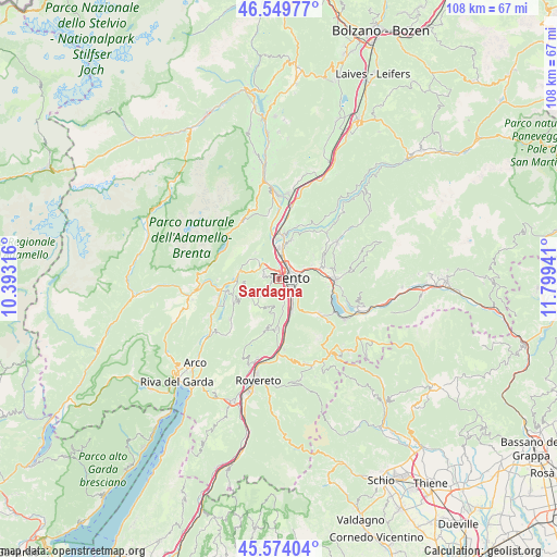
Sardagna GPS coordinates[2]
46° 3' 50.616" North, 11° 5' 46.608" East
| Map corner | latitude | longitude |
|---|---|---|
| Upper-left | 46.54977°, | 10.39316° |
| Center: | 46.06406°, | 11.09628° |
| Lower-right: | 45.57404°, | 11.79941° |
| Map W x H: | 108.5×108.5 km | = 67.4×67.4mi |
| max Lat: | 47.04031° ⇑6.7% North |
| Sardagna: | 46.06406° |
| min Lat: | ⇓93.3% South 35.50142° |
| min Long | Sardagna | max Long |
| 6.69888° | 11.09628° | 18.48682° |
| W 44%⇐ | ⇒56% E |
Elevation
Elevation of Sardagna is 571 m = 1873 ft, and this is 264.3 m = 867 ft above average elevation for this country.
| Max E: |
2085 m = 6841 ft | 17.1% |
| Sardagna | 571 m 1873 ft | |
| Avg. | 306.7 m = 1006 ft | |
Min E: |
-4 m = -13 ft | 82.9% |
See also: Italy elevation on elevation.city.
Geographical zone
Sardagna is located in North temperate zone (between Tropic of Cancer and the Arctic Circle). Distance of this North polar circle is 2279.3 km =1416.3 mi to North.| Distance of | km | miles | from Sardagna |
|---|---|---|---|
| North Pole | 4885.2 | 3035.5 | to North |
| Arctic Circle | 2279.3 | 1416.3 | to North |
| Tropic Cancer | 2515.9 | 1563.3 | to South |
| Equator | 5121.8 | 3182.5 | to South |


Nearby cities:
15 places around Sardagna: (largest is in red/bold)
• Cadine
3.6 km =2.2 mi,  322°
322°
• Civezzano
7.5 km =4.7 mi,  66°
66°
• Garniga Nuova
6.8 km =4.2 mi,  185°
185°
• Gazzadina
7.6 km =4.7 mi,  18°
18°
• Mattarello
6.7 km =4.2 mi,  157°
157°
• Meano
6.9 km =4.3 mi,  13°
13°
• Povo
4.5 km =2.8 mi,  85°
85°
• Ravina
3 km =1.9 mi, 155°
• Romagnano
5.2 km =3.2 mi,  171°
171°
• Tavernaro
5.1 km =3.2 mi, 65°
• Terlago
5.4 km =3.4 mi,  313°
313°
• Trento
2 km =1.2 mi,  77°
77°
• Vela
2.1 km =1.3 mi, 12°
• Vezzano
7.8 km =4.8 mi,  282°
282°
• Villamontagna
5.5 km =3.4 mi,  62°
62°
Sources, notices
• [Note1] Compared only with cities in Italy existing in our database
• [Src1] Map data: © OpenStreetMap contributors (CC-BY-SA)
• [Src2] Other city data from geonames.org with taken over terms of usage.
• [Src3] Geographical zone / Annual Mean Temperature by Robert A. Rohde @ Wikipedia
