Spina geodata
Spina (Umbria) is a populated place; located in Italy in Europe/Rome (GMT+2) time zone. With population of 564 people, there are 9308 cities with bigger population in this country. Compared to other cities in Italy, 63.5% of cities are located further ↑North; 59.6% of cities are located further ←West and 57.3% of cities have lower elevation than Spina. Note1


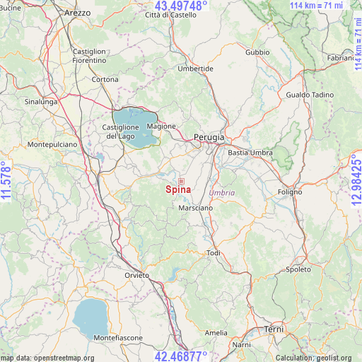
Spina GPS coordinates[2]
42° 59' 7.008" North, 12° 16' 52.032" East
| Map corner | latitude | longitude |
|---|---|---|
| Upper-left | 43.49748°, | 11.578° |
| Center: | 42.98528°, | 12.28112° |
| Lower-right: | 42.46877°, | 12.98425° |
| Map W x H: | 114.4×114.4 km | = 71.1×71.1mi |
| max Lat: | 47.04031° ⇑63.5% North |
| Spina: | 42.98528° |
| min Lat: | ⇓36.5% South 35.50142° |
| min Long | Spina | max Long |
| 6.69888° | 12.28112° | 18.48682° |
| W 59.6%⇐ | ⇒40.4% E |
Elevation
Elevation of Spina is 281 m = 922 ft, and this is 25.7 m = 84 ft below average elevation for this country.
| Max E: |
2085 m = 6841 ft | 42.7% |
| Avg. | 306.7 m = 1006 ft | |
| Spina | 281 m = 922 ft | |
Min E: |
-4 m = -13 ft | 57.3% |
See also: Italy elevation on elevation.city.
Geographical zone
Spina is located in North temperate zone (between Tropic of Cancer and the Arctic Circle). Distance of this Northern Tropic circle is 2173.6 km =1350.6 mi to South.| Distance of | km | miles | from Spina |
|---|---|---|---|
| North Pole | 5227.5 | 3248.2 | to North |
| Arctic Circle | 2621.7 | 1629 | to North |
| Tropic Cancer | 2173.6 | 1350.6 | to South |
| Equator | 4779.5 | 2969.8 | to South |


Nearby cities:
15 places around Spina: (largest is in red/bold)
• Agello
10.1 km =6.3 mi,  340°
340°
• Castiglione della Valle
4.5 km =2.8 mi,  328°
328°
• Cerqueto
4.8 km =3 mi,  140°
140°
• Deruta
11.1 km =6.9 mi,  90°
90°
• Fontignano
8.5 km =5.3 mi,  300°
300°
• Marsciano
9.1 km =5.7 mi, 141°
• Mugnano
9.3 km =5.8 mi, 327°
• Pietrafitta
5.6 km =3.5 mi,  276°
276°
• Pila
8.5 km =5.3 mi,  27°
27°
• Ripabianca
11.2 km =7 mi,  117°
117°
• San Biagio della Valle
4 km =2.5 mi,  8°
8°
• San Niccolò di Celle
9 km =5.6 mi,  67°
67°
• Sant'Angelo di Celle
8.5 km =5.3 mi,  80°
80°
• Sant'Enea
6.8 km =4.2 mi, 66°
• Tavernelle
11.2 km =7 mi, 280°
Sources, notices
• [Note1] Compared only with cities in Italy existing in our database
• [Src1] Map data: © OpenStreetMap contributors (CC-BY-SA)
• [Src2] Other city data from geonames.org with taken over terms of usage.
• [Src3] Geographical zone / Annual Mean Temperature by Robert A. Rohde @ Wikipedia
