Maissana geodata
Maissana (Liguria) is a seat of a third-order administrative division; located in Italy in Europe/Rome (GMT+2) time zone. With population of 45 people, there are 11614 cities with bigger population in this country. Compared to other cities in Italy, 51.4% of cities are located further ↑North; 72.8% of cities are located further →East and 82.1% of cities have lower elevation than Maissana. Note1


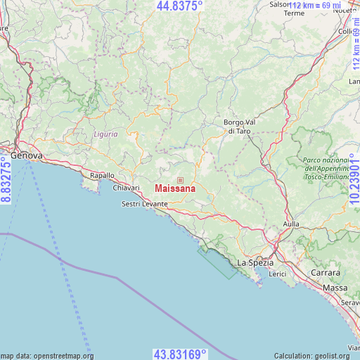
Maissana GPS coordinates[2]
44° 20' 12.3" North, 9° 32' 9.168" East
| Map corner | latitude | longitude |
|---|---|---|
| Upper-left | 44.8375°, | 8.83275° |
| Center: | 44.33675°, | 9.53588° |
| Lower-right: | 43.83169°, | 10.23901° |
| Map W x H: | 111.8×111.8 km | = 69.5×69.5mi |
| max Lat: | 47.04031° ⇑51.4% North |
| Maissana: | 44.33675° |
| min Lat: | ⇓48.6% South 35.50142° |
| min Long | Maissana | max Long |
| 6.69888° | 9.53588° | 18.48682° |
| W 27.2%⇐ | ⇒72.8% E |
Elevation
Elevation of Maissana is 556 m = 1824 ft, and this is 249.3 m = 818 ft above average elevation for this country.
| Max E: |
2085 m = 6841 ft | 17.9% |
| Maissana | 556 m 1824 ft | |
| Avg. | 306.7 m = 1006 ft | |
Min E: |
-4 m = -13 ft | 82.1% |
See also: Italy elevation on elevation.city.
Geographical zone
Maissana is located in North temperate zone (between Tropic of Cancer and the Arctic Circle). Distance of this Northern Tropic circle is 2323.9 km =1444 mi to South.| Distance of | km | miles | from Maissana |
|---|---|---|---|
| North Pole | 5077.3 | 3154.9 | to North |
| Arctic Circle | 2471.4 | 1535.7 | to North |
| Tropic Cancer | 2323.9 | 1444 | to South |
| Equator | 4929.8 | 3063.2 | to South |


Nearby cities:
15 places around Maissana: (largest is in red/bold)
• Carro
9.2 km =5.7 mi,  141°
141°
• Carrodano
14.3 km =8.9 mi, 137°
• Casarza Ligure
10.1 km =6.3 mi,  224°
224°
• Castiglione
7 km =4.3 mi,  192°
192°
• Cogorno
13.2 km =8.2 mi,  262°
262°
• Conscenti
11.2 km =7 mi,  274°
274°
• Deiva Marina
13.1 km =8.1 mi, 185°
• Framura
14.2 km =8.8 mi,  174°
174°
• Mezzanego
13.7 km =8.5 mi,  292°
292°
• Moneglia
11.4 km =7.1 mi,  198°
198°
• Prati
13.7 km =8.5 mi, 291°
• San Salvatore
14.4 km =8.9 mi, 267°
• Sesta Godano
12.1 km =7.5 mi,  113°
113°
• Sestri Levante
13.1 km =8.1 mi,  237°
237°
• Varese Ligure
6.4 km =4 mi,  45°
45°
Sources, notices
• [Note1] Compared only with cities in Italy existing in our database
• [Src1] Map data: © OpenStreetMap contributors (CC-BY-SA)
• [Src2] Other city data from geonames.org with taken over terms of usage.
• [Src3] Geographical zone / Annual Mean Temperature by Robert A. Rohde @ Wikipedia
