Savorgnano geodata
Savorgnano (Friuli Venezia Giulia) is a populated place; located in Italy in Europe/Rome (GMT+2) time zone. With population of 996 people, there are 6686 cities with bigger population in this country. Compared to other cities in Italy, 89.1% of cities are located further ↓South; 66.6% of cities are located further ←West and 87.4% of cities have higher elevation than Savorgnano. Note1
Administrative division(s):
- Level 1: Friuli Venezia Giulia
- Level 2: Provincia di Pordenone
- Level 3: San Vito al Tagliamento


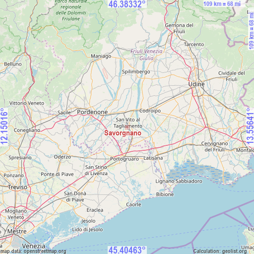
Savorgnano GPS coordinates[2]
45° 53' 46.068" North, 12° 51' 11.808" East
| Map corner | latitude | longitude |
|---|---|---|
| Upper-left | 46.38332°, | 12.15016° |
| Center: | 45.89613°, | 12.85328° |
| Lower-right: | 45.40463°, | 13.55641° |
| Map W x H: | 108.8×108.8 km | = 67.6×67.6mi |
| max Lat: | 47.04031° ⇑10.9% North |
| Savorgnano: | 45.89613° |
| min Lat: | ⇓89.1% South 35.50142° |
| min Long | Savorgnano | max Long |
| 6.69888° | 12.85328° | 18.48682° |
| W 66.6%⇐ | ⇒33.4% E |
Elevation
Elevation of Savorgnano is 24 m = 79 ft, and this is 282.7 m = 927 ft below average elevation for this country.
| Max E: |
2085 m = 6841 ft | 87.4% |
| Avg. | 306.7 m = 1006 ft | |
| Savorgnano | 24 m = 79 ft | |
Min E: |
-4 m = -13 ft | 12.6% |
See also: Italy elevation on elevation.city.
Geographical zone
Savorgnano is located in North temperate zone (between Tropic of Cancer and the Arctic Circle). Distance of this North polar circle is 2298 km =1427.9 mi to North.| Distance of | km | miles | from Savorgnano |
|---|---|---|---|
| North Pole | 4903.9 | 3047.1 | to North |
| Arctic Circle | 2298 | 1427.9 | to North |
| Tropic Cancer | 2497.3 | 1551.7 | to South |
| Equator | 5103.2 | 3171 | to South |


Nearby cities:
15 places around Savorgnano: (largest is in red/bold)
• Bagnarola
3.3 km =2.1 mi,  172°
172°
• Biauzzo
8.7 km =5.4 mi,  43°
43°
• Camino al Tagliamento
7.9 km =4.9 mi,  63°
63°
• Casarsa della Delizia
6.1 km =3.8 mi,  352°
352°
• Casette
5.1 km =3.2 mi,  156°
156°
• Cordovado
6.3 km =3.9 mi, 156°
• Gleris
1.7 km =1.1 mi,  90°
90°
• Gruaro
6.9 km =4.3 mi,  187°
187°
• Gruaro-Bagnara
6.1 km =3.8 mi,  181°
181°
• Morsano
7 km =4.3 mi,  125°
125°
• Ramuscello
2.9 km =1.8 mi,  124°
124°
• Rosa
4.1 km =2.5 mi,  19°
19°
• San Vito al Tagliamento
2.3 km =1.4 mi,  11°
11°
• Sesto al Reghena
6.1 km =3.8 mi,  210°
210°
• Villotta
8.5 km =5.3 mi,  244°
244°
Sources, notices
• [Note1] Compared only with cities in Italy existing in our database
• [Src1] Map data: © OpenStreetMap contributors (CC-BY-SA)
• [Src2] Other city data from geonames.org with taken over terms of usage.
• [Src3] Geographical zone / Annual Mean Temperature by Robert A. Rohde @ Wikipedia
