Licinella-Torre di Paestum geodata
Licinella-Torre di Paestum (Campania) is a populated place; located in Italy in Europe/Rome (GMT+2) time zone. With population of 2,704 people, there are 3301 cities with bigger population in this country. Compared to other cities in Italy, 84.7% of cities are located further ↑North; 87.1% of cities are located further ←West and 94.8% of cities have higher elevation than Licinella-Torre di Paestum. Note1
Administrative division(s):
- Level 1: Campania
- Level 2: Provincia di Salerno
- Level 3: Capaccio Paestum
Current local time in Licinella-Torre di Paestum:
12:30 AM, ThursdayDifference from your time zone: hours


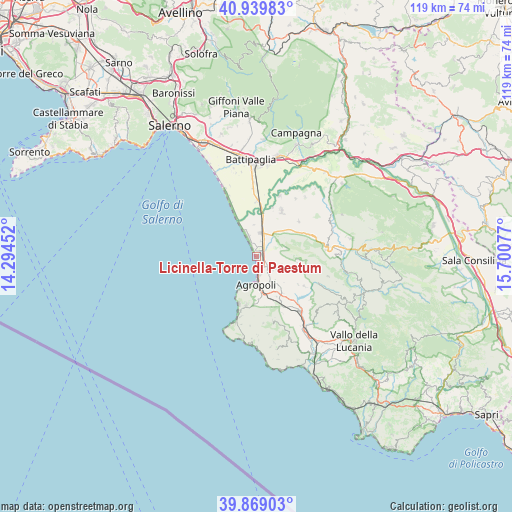
Licinella-Torre di Paestum GPS coordinates[2]
40° 24' 23.616" North, 14° 59' 51.504" East
| Map corner | latitude | longitude |
|---|---|---|
| Upper-left | 40.93983°, | 14.29452° |
| Center: | 40.40656°, | 14.99764° |
| Lower-right: | 39.86903°, | 15.70077° |
| Map W x H: | 119.1×119.1 km | = 74×74mi |
| max Lat: | 47.04031° ⇑84.7% North |
| Licinella-Torre di Paestum: | 40.40656° |
| min Lat: | ⇓15.3% South 35.50142° |
| min Long | Licinella-Torre | max Long |
| 6.69888° | 14.99764° | 18.48682° |
| W 87.1%⇐ | ⇒12.9% E |
Elevation
Elevation of Licinella-Torre di Paestum is 9 m = 30 ft, and this is 297.7 m = 977 ft below average elevation for this country.
| Max E: |
2085 m = 6841 ft | 94.8% |
| Avg. | 306.7 m = 1006 ft | |
| Licinella-Torre di Paestum | 9 m = 30 ft | |
Min E: |
-4 m = -13 ft | 5.2% |
See also: Italy elevation on elevation.city.
Geographical zone
Licinella-Torre di Paestum is located in North temperate zone (between Tropic of Cancer and the Arctic Circle). Distance of this Northern Tropic circle is 1886.9 km =1172.5 mi to South.| Distance of | km | miles | from Licinella-Torre di Paestum |
|---|---|---|---|
| North Pole | 5514.3 | 3426.4 | to North |
| Arctic Circle | 2908.4 | 1807.2 | to North |
| Tropic Cancer | 1886.9 | 1172.5 | to South |
| Equator | 4492.8 | 2791.7 | to South |


Nearby cities:
15 places around Licinella-Torre di Paestum: (largest is in red/bold)
• Agropoli
6.4 km =4 mi,  185°
185°
• Alano
11.4 km =7.1 mi, 191°
• Cafasso-Borgo Nuovo
3.7 km =2.3 mi,  17°
17°
• Capaccio
7.2 km =4.5 mi,  74°
74°
• Capaccio Scalo
5.5 km =3.4 mi,  9°
9°
• Giungano
9.4 km =5.8 mi,  98°
98°
• Laura
2.9 km =1.8 mi,  345°
345°
• Mattine
3.3 km =2.1 mi,  134°
134°
• Ogliastro Cilento
7.4 km =4.6 mi,  146°
146°
• Ponte Barizzo
9.8 km =6.1 mi, 9°
• Prignano Cilento
10.1 km =6.3 mi,  144°
144°
• Rettifilo-Vannullo
5.6 km =3.5 mi,  27°
27°
• Santa Venere
1.3 km =0.8 mi, 70°
• Torchiara
10.6 km =6.6 mi, 153°
• Trentinara
10 km =6.2 mi,  94°
94°
Sources, notices
• [Note1] Compared only with cities in Italy existing in our database
• [Src1] Map data: © OpenStreetMap contributors (CC-BY-SA)
• [Src2] Other city data from geonames.org with taken over terms of usage.
• [Src3] Geographical zone / Annual Mean Temperature by Robert A. Rohde @ Wikipedia
