Gambatesa geodata
Gambatesa (Molise) is a seat of a third-order administrative division; located in Italy in Europe/Rome (GMT+2) time zone. With population of 1,241 people, there are 5824 cities with bigger population in this country. Compared to other cities in Italy, 74.8% of cities are located further ↑North; 86.5% of cities are located further ←West and 76.8% of cities have lower elevation than Gambatesa. Note1


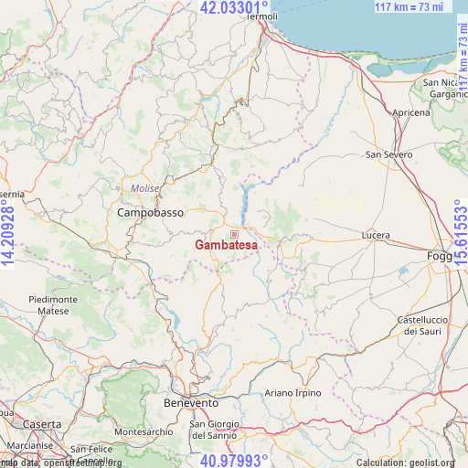
Gambatesa GPS coordinates[2]
41° 30' 30.996" North, 14° 54' 44.64" East
| Map corner | latitude | longitude |
|---|---|---|
| Upper-left | 42.03301°, | 14.20928° |
| Center: | 41.50861°, | 14.9124° |
| Lower-right: | 40.97993°, | 15.61553° |
| Map W x H: | 117.1×117.1 km | = 72.8×72.8mi |
| max Lat: | 47.04031° ⇑74.8% North |
| Gambatesa: | 41.50861° |
| min Lat: | ⇓25.2% South 35.50142° |
| min Long | Gambatesa | max Long |
| 6.69888° | 14.9124° | 18.48682° |
| W 86.5%⇐ | ⇒13.5% E |
Elevation
Elevation of Gambatesa is 477 m = 1565 ft, and this is 170.3 m = 559 ft above average elevation for this country.
| Max E: |
2085 m = 6841 ft | 23.2% |
| Gambatesa | 477 m 1565 ft | |
| Avg. | 306.7 m = 1006 ft | |
Min E: |
-4 m = -13 ft | 76.8% |
See also: Italy elevation on elevation.city.
Geographical zone
Gambatesa is located in North temperate zone (between Tropic of Cancer and the Arctic Circle). Distance of this Northern Tropic circle is 2009.4 km =1248.6 mi to South.| Distance of | km | miles | from Gambatesa |
|---|---|---|---|
| North Pole | 5391.7 | 3350.2 | to North |
| Arctic Circle | 2785.8 | 1731 | to North |
| Tropic Cancer | 2009.4 | 1248.6 | to South |
| Equator | 4615.3 | 2867.8 | to South |


Nearby cities:
15 places around Gambatesa: (largest is in red/bold)
• Baselice
13.8 km =8.6 mi,  158°
158°
• Carlantino
10.9 km =6.8 mi,  29°
29°
• Castelvetere in Val Fortore
7.7 km =4.8 mi, 161°
• Celenza Valfortore
8 km =5 mi,  43°
43°
• Gildone
14.3 km =8.9 mi,  270°
270°
• Jelsi
9.6 km =6 mi,  275°
275°
• Macchia Valfortore
9.6 km =6 mi,  359°
359°
• Monacilioni
14.2 km =8.8 mi,  323°
323°
• Pietracatella
8.7 km =5.4 mi,  337°
337°
• Riccia
7.3 km =4.5 mi,  247°
247°
• San Bartolomeo in Galdo
13.5 km =8.4 mi,  139°
139°
• San Marco la Catola
8 km =5 mi,  76°
76°
• Sant'Elia a Pianisi
12.8 km =8 mi,  346°
346°
• Tufara
4.1 km =2.5 mi, 136°
• Volturara Appula
11.7 km =7.3 mi,  96°
96°
Sources, notices
• [Note1] Compared only with cities in Italy existing in our database
• [Src1] Map data: © OpenStreetMap contributors (CC-BY-SA)
• [Src2] Other city data from geonames.org with taken over terms of usage.
• [Src3] Geographical zone / Annual Mean Temperature by Robert A. Rohde @ Wikipedia
