Riccia geodata
Riccia (Molise) is a seat of a third-order administrative division; located in Italy in Europe/Rome (GMT+2) time zone. With population of 3,784 people, there are 2518 cities with bigger population in this country. Compared to other cities in Italy, 75% of cities are located further ↑North; 85.8% of cities are located further ←West and 89.4% of cities have lower elevation than Riccia. Note1


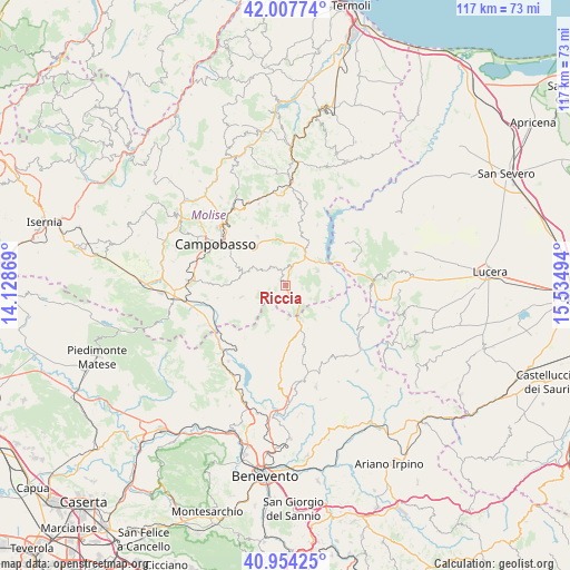
Riccia GPS coordinates[2]
41° 28' 59.304" North, 14° 49' 54.516" East
| Map corner | latitude | longitude |
|---|---|---|
| Upper-left | 42.00774°, | 14.12869° |
| Center: | 41.48314°, | 14.83181° |
| Lower-right: | 40.95425°, | 15.53494° |
| Map W x H: | 117.1×117.1 km | = 72.8×72.8mi |
| max Lat: | 47.04031° ⇑75% North |
| Riccia: | 41.48314° |
| min Lat: | ⇓25% South 35.50142° |
| min Long | Riccia | max Long |
| 6.69888° | 14.83181° | 18.48682° |
| W 85.8%⇐ | ⇒14.2% E |
Elevation
Elevation of Riccia is 704 m = 2310 ft, and this is 397.3 m = 1303 ft above average elevation for this country.
| Max E: |
2085 m = 6841 ft | 10.6% |
| Riccia | 704 m 2310 ft | |
| Avg. | 306.7 m = 1006 ft | |
Min E: |
-4 m = -13 ft | 89.4% |
See also: Italy elevation on elevation.city.
Geographical zone
Riccia is located in North temperate zone (between Tropic of Cancer and the Arctic Circle). Distance of this Northern Tropic circle is 2006.6 km =1246.8 mi to South.| Distance of | km | miles | from Riccia |
|---|---|---|---|
| North Pole | 5394.6 | 3352 | to North |
| Arctic Circle | 2788.7 | 1732.8 | to North |
| Tropic Cancer | 2006.6 | 1246.8 | to South |
| Equator | 4612.5 | 2866.1 | to South |


Nearby cities:
15 places around Riccia: (largest is in red/bold)
• Campodipietra
11 km =6.8 mi,  318°
318°
• Castelpagano
9.3 km =5.8 mi,  192°
192°
• Castelvetere in Val Fortore
10.2 km =6.3 mi,  116°
116°
• Cercemaggiore
9.3 km =5.8 mi,  254°
254°
• Colle Sannita
13.3 km =8.3 mi,  179°
179°
• Gambatesa
7.3 km =4.5 mi,  67°
67°
• Gildone
8.2 km =5.1 mi,  290°
290°
• Jelsi
4.7 km =2.9 mi, 323°
• Macchia Valfortore
14.1 km =8.8 mi,  28°
28°
• Mirabello Sannitico
13.7 km =8.5 mi, 285°
• Pietracatella
11.4 km =7.1 mi,  17°
17°
• San Giovanni in Galdo
13.7 km =8.5 mi,  331°
331°
• Santa Croce del Sannio
13.4 km =8.3 mi,  218°
218°
• Toro
11.6 km =7.2 mi, 329°
• Tufara
9.6 km =6 mi,  90°
90°
Sources, notices
• [Note1] Compared only with cities in Italy existing in our database
• [Src1] Map data: © OpenStreetMap contributors (CC-BY-SA)
• [Src2] Other city data from geonames.org with taken over terms of usage.
• [Src3] Geographical zone / Annual Mean Temperature by Robert A. Rohde @ Wikipedia
