Arten geodata
Arten (Veneto) is a populated place; located in Italy in Europe/Rome (GMT+2) time zone. With population of 930 people, there are 6983 cities with bigger population in this country. Compared to other cities in Italy, 92.2% of cities are located further ↓South; 53.6% of cities are located further ←West and 60.9% of cities have lower elevation than Arten. Note1


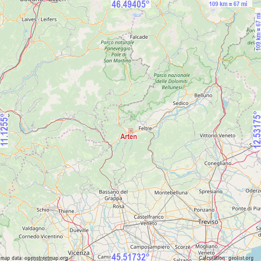
Arten GPS coordinates[2]
46° 0' 28.224" North, 11° 49' 43.032" East
| Map corner | latitude | longitude |
|---|---|---|
| Upper-left | 46.49405°, | 11.1255° |
| Center: | 46.00784°, | 11.82862° |
| Lower-right: | 45.51732°, | 12.53175° |
| Map W x H: | 108.6×108.6 km | = 67.5×67.5mi |
| max Lat: | 47.04031° ⇑7.8% North |
| Arten: | 46.00784° |
| min Lat: | ⇓92.2% South 35.50142° |
| min Long | Arten | max Long |
| 6.69888° | 11.82862° | 18.48682° |
| W 53.6%⇐ | ⇒46.4% E |
Elevation
Elevation of Arten is 306 m = 1004 ft, and this is 0.69999999999999 m = 2 ft below average elevation for this country.
| Max E: |
2085 m = 6841 ft | 39.1% |
| Avg. | 306.7 m = 1006 ft | |
| Arten | 306 m = 1004 ft | |
Min E: |
-4 m = -13 ft | 60.9% |
See also: Italy elevation on elevation.city.
Geographical zone
Arten is located in North temperate zone (between Tropic of Cancer and the Arctic Circle). Distance of this North polar circle is 2285.6 km =1420.2 mi to North.| Distance of | km | miles | from Arten |
|---|---|---|---|
| North Pole | 4891.5 | 3039.4 | to North |
| Arctic Circle | 2285.6 | 1420.2 | to North |
| Tropic Cancer | 2509.7 | 1559.5 | to South |
| Equator | 5115.6 | 3178.7 | to South |


Nearby cities:
15 places around Arten: (largest is in red/bold)
• Anzù
8.1 km =5 mi,  89°
89°
• Arsiè
6.2 km =3.9 mi,  242°
242°
• Enego
12 km =7.5 mi,  232°
232°
• Facen-Travagola
3.6 km =2.2 mi,  48°
48°
• Feltre
5.7 km =3.5 mi,  75°
75°
• Foen
7.3 km =4.5 mi,  59°
59°
• Fonzaso
2.5 km =1.6 mi,  292°
292°
• Lamon
7.5 km =4.7 mi,  305°
305°
• Pedavena
5.5 km =3.4 mi, 50°
• Seren del Grappa
2.5 km =1.6 mi,  121°
121°
• Servo
6.5 km =4 mi,  330°
330°
• Sovramonte
6.5 km =4 mi, 330°
• Tezze
12.4 km =7.7 mi,  261°
261°
• Vas
11.3 km =7 mi,  133°
133°
• Villabruna-Umin
9.3 km =5.8 mi, 54°
Sources, notices
• [Note1] Compared only with cities in Italy existing in our database
• [Src1] Map data: © OpenStreetMap contributors (CC-BY-SA)
• [Src2] Other city data from geonames.org with taken over terms of usage.
• [Src3] Geographical zone / Annual Mean Temperature by Robert A. Rohde @ Wikipedia
