Castelnuovo geodata
Castelnuovo (Abruzzo) is a populated place; located in Italy in Europe/Rome (GMT+2) time zone. With population of 738 people, there are 8032 cities with bigger population in this country. Compared to other cities in Italy, 65% of cities are located further ↑North; 75.6% of cities are located further ←West and 67.1% of cities have lower elevation than Castelnuovo. Note1


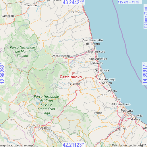
Castelnuovo GPS coordinates[2]
42° 43' 47.532" North, 13° 41' 45.744" East
| Map corner | latitude | longitude |
|---|---|---|
| Upper-left | 43.24421°, | 12.99292° |
| Center: | 42.72987°, | 13.69604° |
| Lower-right: | 42.21123°, | 14.39917° |
| Map W x H: | 114.9×114.9 km | = 71.4×71.4mi |
| max Lat: | 47.04031° ⇑65% North |
| Castelnuovo: | 42.72987° |
| min Lat: | ⇓35% South 35.50142° |
| min Long | Castelnuovo | max Long |
| 6.69888° | 13.69604° | 18.48682° |
| W 75.6%⇐ | ⇒24.4% E |
Elevation
Elevation of Castelnuovo is 364 m = 1194 ft, and this is 57.3 m = 188 ft above average elevation for this country.
| Max E: |
2085 m = 6841 ft | 32.9% |
| Castelnuovo | 364 m 1194 ft | |
| Avg. | 306.7 m = 1006 ft | |
Min E: |
-4 m = -13 ft | 67.1% |
See also: Italy elevation on elevation.city.
Geographical zone
Castelnuovo is located in North temperate zone (between Tropic of Cancer and the Arctic Circle). Distance of this Northern Tropic circle is 2145.2 km =1333 mi to South.| Distance of | km | miles | from Castelnuovo |
|---|---|---|---|
| North Pole | 5255.9 | 3265.9 | to North |
| Arctic Circle | 2650.1 | 1646.7 | to North |
| Tropic Cancer | 2145.2 | 1333 | to South |
| Equator | 4751.1 | 2952.2 | to South |


Nearby cities:
15 places around Castelnuovo: (largest is in red/bold)
• Bellante
8.8 km =5.5 mi,  79°
79°
• Campli
0.8 km =0.5 mi,  245°
245°
• Cannelli
4.9 km =3 mi,  172°
172°
• Civitella del Tronto
5.1 km =3.2 mi,  341°
341°
• Colle Santa Maria-Varano
3.4 km =2.1 mi,  143°
143°
• Colleatterrato Alto
6.2 km =3.9 mi,  153°
153°
• Nepezzano
6.6 km =4.1 mi,  131°
131°
• Piano d'Accio
7.2 km =4.5 mi, 135°
• Putignano
5.9 km =3.7 mi,  206°
206°
• San Nicolò a Tordino
9.1 km =5.7 mi,  114°
114°
• Sant'Onofrio-Floriano
4.9 km =3 mi,  43°
43°
• Santa Croce
8.1 km =5 mi,  20°
20°
• Teramo
7.6 km =4.7 mi,  178°
178°
• Torricella
8.5 km =5.3 mi,  201°
201°
• Villa Lempa
8.2 km =5.1 mi,  329°
329°
Sources, notices
• [Note1] Compared only with cities in Italy existing in our database
• [Src1] Map data: © OpenStreetMap contributors (CC-BY-SA)
• [Src2] Other city data from geonames.org with taken over terms of usage.
• [Src3] Geographical zone / Annual Mean Temperature by Robert A. Rohde @ Wikipedia
