Flavon geodata
Flavon (Trentino-Alto Adige) is a seat of a third-order administrative division; located in Italy in Europe/Rome (GMT+2) time zone. With population of 483 people, there are 9983 cities with bigger population in this country. Compared to other cities in Italy, 96.9% of cities are located further ↓South; 56.9% of cities are located further →East and 83.9% of cities have lower elevation than Flavon. Note1
Administrative division(s):
- Level 1: Trentino-Alto Adige
- Level 2: Provincia autonoma di Trento
- Level 3: Contà


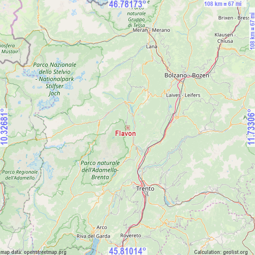
Flavon GPS coordinates[2]
46° 17' 53.124" North, 11° 1' 47.748" East
| Map corner | latitude | longitude |
|---|---|---|
| Upper-left | 46.78173°, | 10.32681° |
| Center: | 46.29809°, | 11.02993° |
| Lower-right: | 45.81014°, | 11.73306° |
| Map W x H: | 108×108 km | = 67.1×67.1mi |
| max Lat: | 47.04031° ⇑3.1% North |
| Flavon: | 46.29809° |
| min Lat: | ⇓96.9% South 35.50142° |
| min Long | Flavon | max Long |
| 6.69888° | 11.02993° | 18.48682° |
| W 43.1%⇐ | ⇒56.9% E |
Elevation
Elevation of Flavon is 589 m = 1932 ft, and this is 282.3 m = 926 ft above average elevation for this country.
| Max E: |
2085 m = 6841 ft | 16.1% |
| Flavon | 589 m 1932 ft | |
| Avg. | 306.7 m = 1006 ft | |
Min E: |
-4 m = -13 ft | 83.9% |
See also: Italy elevation on elevation.city.
Geographical zone
Flavon is located in North temperate zone (between Tropic of Cancer and the Arctic Circle). Distance of this North polar circle is 2253.3 km =1400.1 mi to North.| Distance of | km | miles | from Flavon |
|---|---|---|---|
| North Pole | 4859.2 | 3019.4 | to North |
| Arctic Circle | 2253.3 | 1400.1 | to North |
| Tropic Cancer | 2541.9 | 1579.5 | to South |
| Equator | 5147.9 | 3198.8 | to South |


Nearby cities:
15 places around Flavon: (largest is in red/bold)
• Campodenno
4.5 km =2.8 mi,  176°
176°
• Cles
7.2 km =4.5 mi,  1°
1°
• Coredo
7.3 km =4.5 mi,  39°
39°
• Cunevo
1.3 km =0.8 mi,  164°
164°
• Denno
3 km =1.9 mi,  150°
150°
• Nanno
2.3 km =1.4 mi, 35°
• Segno
3.5 km =2.2 mi,  76°
76°
• Sporminore
6.8 km =4.2 mi, 180°
• Taio
3.8 km =2.4 mi,  47°
47°
• Tassullo
5.1 km =3.2 mi,  13°
13°
• Terres
1.4 km =0.9 mi,  338°
338°
• Tres
5.8 km =3.6 mi,  62°
62°
• Tuenno
3.4 km =2.1 mi,  351°
351°
• Vervò
7 km =4.3 mi, 79°
• Vigo di Ton
5.8 km =3.6 mi,  129°
129°
Sources, notices
• [Note1] Compared only with cities in Italy existing in our database
• [Src1] Map data: © OpenStreetMap contributors (CC-BY-SA)
• [Src2] Other city data from geonames.org with taken over terms of usage.
• [Src3] Geographical zone / Annual Mean Temperature by Robert A. Rohde @ Wikipedia
