Cusercoli geodata
Cusercoli (Emilia-Romagna) is a populated place; located in Italy in Europe/Rome (GMT+2) time zone. With population of 1,076 people, there are 6383 cities with bigger population in this country. Compared to other cities in Italy, 54.3% of cities are located further ↑North; 56% of cities are located further ←West and 67.1% of cities have higher elevation than Cusercoli. Note1
Administrative division(s):
- Level 1: Emilia-Romagna
- Level 2: Provincia di Forlì-Cesena
- Level 3: Civitella di Romagna


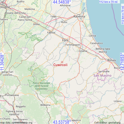
Cusercoli GPS coordinates[2]
44° 2' 42.504" North, 12° 0' 26.64" East
| Map corner | latitude | longitude |
|---|---|---|
| Upper-left | 44.54838°, | 11.30428° |
| Center: | 44.04514°, | 12.0074° |
| Lower-right: | 43.53758°, | 12.71053° |
| Map W x H: | 112.4×112.4 km | = 69.8×69.8mi |
| max Lat: | 47.04031° ⇑54.3% North |
| Cusercoli: | 44.04514° |
| min Lat: | ⇓45.7% South 35.50142° |
| min Long | Cusercoli | max Long |
| 6.69888° | 12.0074° | 18.48682° |
| W 56%⇐ | ⇒44% E |
Elevation
Elevation of Cusercoli is 115 m = 377 ft, and this is 191.7 m = 629 ft below average elevation for this country.
| Max E: |
2085 m = 6841 ft | 67.1% |
| Avg. | 306.7 m = 1006 ft | |
| Cusercoli | 115 m = 377 ft | |
Min E: |
-4 m = -13 ft | 32.9% |
See also: Italy elevation on elevation.city.
Geographical zone
Cusercoli is located in North temperate zone (between Tropic of Cancer and the Arctic Circle). Distance of this Northern Tropic circle is 2291.4 km =1423.8 mi to South.| Distance of | km | miles | from Cusercoli |
|---|---|---|---|
| North Pole | 5109.7 | 3175 | to North |
| Arctic Circle | 2503.8 | 1555.8 | to North |
| Tropic Cancer | 2291.4 | 1423.8 | to South |
| Equator | 4897.4 | 3043.1 | to South |


Nearby cities:
15 places around Cusercoli: (largest is in red/bold)
• Bertinoro
15.5 km =9.6 mi,  41°
41°
• Bora Bassa
13.8 km =8.6 mi,  89°
89°
• Borello
13.9 km =8.6 mi,  83°
83°
• Castrocaro Terme
15.2 km =9.4 mi,  342°
342°
• Civitella di Romagna
6.5 km =4 mi,  230°
230°
• Dovadola
12.9 km =8 mi,  311°
311°
• Fiumana
11 km =6.8 mi,  351°
351°
• Fratta Terme
13.1 km =8.1 mi, 35°
• Galeata
9.5 km =5.9 mi, 234°
• Meldola
10.2 km =6.3 mi,  25°
25°
• Predappio
6.7 km =4.2 mi, 343°
• Rocca San Casciano
13.2 km =8.2 mi,  276°
276°
• San Colombano
6.8 km =4.2 mi, 29°
• San Lorenzo in Noceto
12.9 km =8 mi,  359°
359°
• Santa Sofia
13.4 km =8.3 mi,  215°
215°
Sources, notices
• [Note1] Compared only with cities in Italy existing in our database
• [Src1] Map data: © OpenStreetMap contributors (CC-BY-SA)
• [Src2] Other city data from geonames.org with taken over terms of usage.
• [Src3] Geographical zone / Annual Mean Temperature by Robert A. Rohde @ Wikipedia
