Ferrera Erbognone geodata
Ferrera Erbognone (Lombardy) is a seat of a third-order administrative division; located in Italy in Europe/Rome (GMT+2) time zone. With population of 1,039 people, there are 6510 cities with bigger population in this country. Compared to other cities in Italy, 62.8% of cities are located further ↓South; 83.3% of cities are located further →East and 71.3% of cities have higher elevation than Ferrera Erbognone. Note1
Administrative division(s):
- Level 1: Lombardy
- Level 2: Provincia di Pavia
- Level 3: Ferrera Erbognone


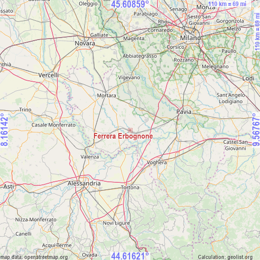
Ferrera Erbognone GPS coordinates[2]
45° 6' 52.416" North, 8° 51' 52.344" East
| Map corner | latitude | longitude |
|---|---|---|
| Upper-left | 45.60859°, | 8.16142° |
| Center: | 45.11456°, | 8.86454° |
| Lower-right: | 44.61621°, | 9.56767° |
| Map W x H: | 110.3×110.3 km | = 68.5×68.5mi |
| max Lat: | 47.04031° ⇑37.2% North |
| Ferrera Erbognone: | 45.11456° |
| min Lat: | ⇓62.8% South 35.50142° |
| min Long | Ferrera Erbogno | max Long |
| 6.69888° | 8.86454° | 18.48682° |
| W 16.7%⇐ | ⇒83.3% E |
Elevation
Elevation of Ferrera Erbognone is 91 m = 299 ft, and this is 215.7 m = 708 ft below average elevation for this country.
| Max E: |
2085 m = 6841 ft | 71.3% |
| Avg. | 306.7 m = 1006 ft | |
| Ferrera Erbognone | 91 m = 299 ft | |
Min E: |
-4 m = -13 ft | 28.7% |
See also: Italy elevation on elevation.city.
Geographical zone
Ferrera Erbognone is located in North temperate zone (between Tropic of Cancer and the Arctic Circle). Distance of this North polar circle is 2384.9 km =1481.9 mi to North.| Distance of | km | miles | from Ferrera Erbognone |
|---|---|---|---|
| North Pole | 4990.8 | 3101.1 | to North |
| Arctic Circle | 2384.9 | 1481.9 | to North |
| Tropic Cancer | 2410.3 | 1497.7 | to South |
| Equator | 5016.3 | 3117 | to South |


Nearby cities:
15 places around Ferrera Erbognone: (largest is in red/bold)
• Alagna
6.4 km =4 mi,  17°
17°
• Bastida de' Dossi
9.4 km =5.8 mi,  151°
151°
• Cornale
8.7 km =5.4 mi,  155°
155°
• Dorno
8 km =5 mi,  57°
57°
• Galliavola
4.1 km =2.5 mi,  242°
242°
• Lomello
5.4 km =3.4 mi,  276°
276°
• Mezzana Bigli
6.2 km =3.9 mi,  192°
192°
• Ottobiano
5.1 km =3.2 mi,  329°
329°
• Pieve Albignola
7.5 km =4.7 mi,  91°
91°
• Pieve del Cairo
8.7 km =5.4 mi,  213°
213°
• San Giorgio di Lomellina
8.9 km =5.5 mi,  318°
318°
• Sannazzaro de' Burgondi
3.6 km =2.2 mi,  112°
112°
• Scaldasole
3.8 km =2.4 mi,  72°
72°
• Valeggio
4 km =2.5 mi,  356°
356°
• Villa Biscossi
6.6 km =4.1 mi,  246°
246°
Sources, notices
• [Note1] Compared only with cities in Italy existing in our database
• [Src1] Map data: © OpenStreetMap contributors (CC-BY-SA)
• [Src2] Other city data from geonames.org with taken over terms of usage.
• [Src3] Geographical zone / Annual Mean Temperature by Robert A. Rohde @ Wikipedia
