Galliavola geodata
Galliavola (Lombardy) is a seat of a third-order administrative division; located in Italy in Europe/Rome (GMT+2) time zone. With population of 207 people, there are 11100 cities with bigger population in this country. Compared to other cities in Italy, 62.3% of cities are located further ↓South; 83.9% of cities are located further →East and 71.1% of cities have higher elevation than Galliavola. Note1


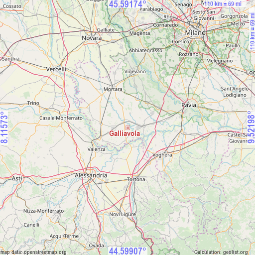
Galliavola GPS coordinates[2]
45° 5' 51.216" North, 8° 49' 7.86" East
| Map corner | latitude | longitude |
|---|---|---|
| Upper-left | 45.59174°, | 8.11573° |
| Center: | 45.09756°, | 8.81885° |
| Lower-right: | 44.59907°, | 9.52198° |
| Map W x H: | 110.4×110.4 km | = 68.6×68.6mi |
| max Lat: | 47.04031° ⇑37.7% North |
| Galliavola: | 45.09756° |
| min Lat: | ⇓62.3% South 35.50142° |
| min Long | Galliavola | max Long |
| 6.69888° | 8.81885° | 18.48682° |
| W 16.1%⇐ | ⇒83.9% E |
Elevation
Elevation of Galliavola is 92 m = 302 ft, and this is 214.7 m = 704 ft below average elevation for this country.
| Max E: |
2085 m = 6841 ft | 71.1% |
| Avg. | 306.7 m = 1006 ft | |
| Galliavola | 92 m = 302 ft | |
Min E: |
-4 m = -13 ft | 28.9% |
See also: Italy elevation on elevation.city.
Geographical zone
Galliavola is located in North temperate zone (between Tropic of Cancer and the Arctic Circle). Distance of this North polar circle is 2386.8 km =1483.1 mi to North.| Distance of | km | miles | from Galliavola |
|---|---|---|---|
| North Pole | 4992.7 | 3102.3 | to North |
| Arctic Circle | 2386.8 | 1483.1 | to North |
| Tropic Cancer | 2408.5 | 1496.6 | to South |
| Equator | 5014.4 | 3115.8 | to South |


Nearby cities:
15 places around Galliavola: (largest is in red/bold)
• Cornale
9.4 km =5.8 mi,  129°
129°
• Ferrera Erbognone
4.1 km =2.5 mi,  62°
62°
• Gambarana
8.8 km =5.5 mi,  209°
209°
• Isola Sant'Antonio
7.9 km =4.9 mi,  162°
162°
• Lomello
3.1 km =1.9 mi,  324°
324°
• Mede
6.4 km =4 mi,  269°
269°
• Mezzana Bigli
4.7 km =2.9 mi,  151°
151°
• Ottobiano
6.4 km =4 mi,  9°
9°
• Pieve del Cairo
5.5 km =3.4 mi,  192°
192°
• San Giorgio di Lomellina
8.9 km =5.5 mi,  345°
345°
• Sannazzaro de' Burgondi
6.9 km =4.3 mi,  85°
85°
• Scaldasole
7.8 km =4.8 mi,  67°
67°
• Semiana
8.3 km =5.2 mi,  302°
302°
• Valeggio
6.8 km =4.2 mi,  29°
29°
• Villa Biscossi
2.6 km =1.6 mi,  252°
252°
Sources, notices
• [Note1] Compared only with cities in Italy existing in our database
• [Src1] Map data: © OpenStreetMap contributors (CC-BY-SA)
• [Src2] Other city data from geonames.org with taken over terms of usage.
• [Src3] Geographical zone / Annual Mean Temperature by Robert A. Rohde @ Wikipedia
