Falzes geodata
Falzes (Trentino-Alto Adige) is a seat of a third-order administrative division; located in Italy in Europe/Rome (GMT+2) time zone. With population of 1,754 people, there are 4560 cities with bigger population in this country. Compared to other cities in Italy, 99.7% of cities are located further ↓South; 54.3% of cities are located further ←West and 97.4% of cities have lower elevation than Falzes. Note1


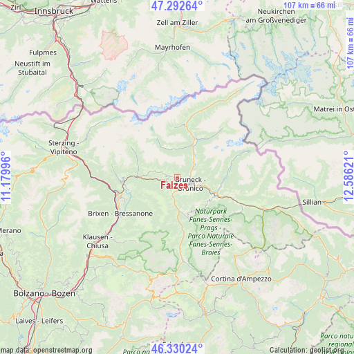
Falzes GPS coordinates[2]
46° 48' 48.924" North, 11° 52' 59.088" East
| Map corner | latitude | longitude |
|---|---|---|
| Upper-left | 47.29264°, | 11.17996° |
| Center: | 46.81359°, | 11.88308° |
| Lower-right: | 46.33024°, | 12.58621° |
| Map W x H: | 107×107 km | = 66.5×66.5mi |
| max Lat: | 47.04031° ⇑0.3% North |
| Falzes: | 46.81359° |
| min Lat: | ⇓99.7% South 35.50142° |
| min Long | Falzes | max Long |
| 6.69888° | 11.88308° | 18.48682° |
| W 54.3%⇐ | ⇒45.7% E |
Elevation
Elevation of Falzes is 1032 m = 3386 ft, and this is 725.3 m = 2380 ft above average elevation for this country.
| Max E: |
2085 m = 6841 ft | 2.6% |
| Falzes | 1032 m 3386 ft | |
| Avg. | 306.7 m = 1006 ft | |
Min E: |
-4 m = -13 ft | 97.4% |
See also: Italy elevation on elevation.city.
Geographical zone
Falzes is located in North temperate zone (between Tropic of Cancer and the Arctic Circle). Distance of this North polar circle is 2196 km =1364.5 mi to North.| Distance of | km | miles | from Falzes |
|---|---|---|---|
| North Pole | 4801.9 | 2983.8 | to North |
| Arctic Circle | 2196 | 1364.5 | to North |
| Tropic Cancer | 2599.3 | 1615.1 | to South |
| Equator | 5205.2 | 3234.4 | to South |


Nearby cities:
15 places around Falzes: (largest is in red/bold)
• Brunico
4.2 km =2.6 mi,  112°
112°
• Casteldarne
3.6 km =2.2 mi,  242°
242°
• Chienes
3.4 km =2.1 mi,  257°
257°
• Gais
5.7 km =3.5 mi,  63°
63°
• Mühlen in Taufers
10.6 km =6.6 mi,  25°
25°
• Perca
8 km =5 mi, 106°
• Riscone
6.6 km =4.1 mi,  128°
128°
• San Lorenzo di Sebato
3.7 km =2.3 mi,  148°
148°
• San Martino
4.2 km =2.6 mi,  164°
164°
• San Sigismondo
6.1 km =3.8 mi,  267°
267°
• Selva dei Molini
8.7 km =5.4 mi,  347°
347°
• Teodone
5.4 km =3.4 mi,  102°
102°
• Terento
7.8 km =4.8 mi,  283°
283°
• Uttenheim
7.5 km =4.7 mi,  40°
40°
• Vandoies di Sopra
10.5 km =6.5 mi, 270°
Sources, notices
• [Note1] Compared only with cities in Italy existing in our database
• [Src1] Map data: © OpenStreetMap contributors (CC-BY-SA)
• [Src2] Other city data from geonames.org with taken over terms of usage.
• [Src3] Geographical zone / Annual Mean Temperature by Robert A. Rohde @ Wikipedia
