Andalo geodata
Andalo (Trentino-Alto Adige) is a seat of a third-order administrative division; located in Italy in Europe/Rome (GMT+2) time zone. With population of 1,005 people, there are 6642 cities with bigger population in this country. Compared to other cities in Italy, 95.4% of cities are located further ↓South; 57.3% of cities are located further →East and 97.3% of cities have lower elevation than Andalo. Note1
Administrative division(s):
- Level 1: Trentino-Alto Adige
- Level 2: Provincia autonoma di Trento
- Level 3: Andalo


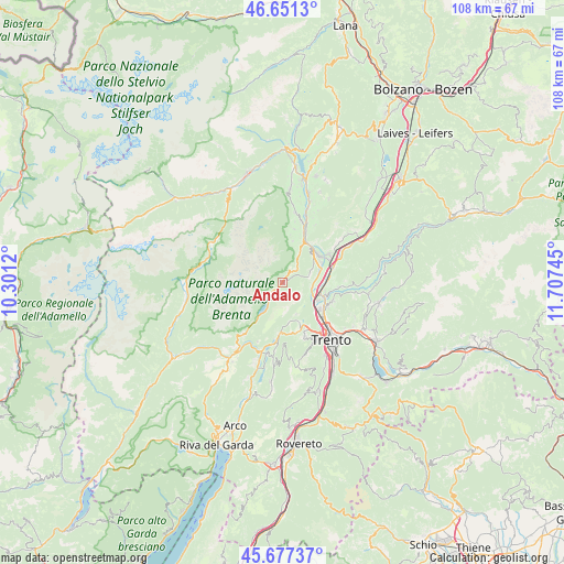
Andalo GPS coordinates[2]
46° 9' 59.364" North, 11° 0' 15.552" East
| Map corner | latitude | longitude |
|---|---|---|
| Upper-left | 46.6513°, | 10.3012° |
| Center: | 46.16649°, | 11.00432° |
| Lower-right: | 45.67737°, | 11.70745° |
| Map W x H: | 108.3×108.3 km | = 67.3×67.3mi |
| max Lat: | 47.04031° ⇑4.6% North |
| Andalo: | 46.16649° |
| min Lat: | ⇓95.4% South 35.50142° |
| min Long | Andalo | max Long |
| 6.69888° | 11.00432° | 18.48682° |
| W 42.7%⇐ | ⇒57.3% E |
Elevation
Elevation of Andalo is 1024 m = 3360 ft, and this is 717.3 m = 2353 ft above average elevation for this country.
| Max E: |
2085 m = 6841 ft | 2.7% |
| Andalo | 1024 m 3360 ft | |
| Avg. | 306.7 m = 1006 ft | |
Min E: |
-4 m = -13 ft | 97.3% |
See also: Italy elevation on elevation.city.
Geographical zone
Andalo is located in North temperate zone (between Tropic of Cancer and the Arctic Circle). Distance of this North polar circle is 2267.9 km =1409.2 mi to North.| Distance of | km | miles | from Andalo |
|---|---|---|---|
| North Pole | 4873.8 | 3028.4 | to North |
| Arctic Circle | 2267.9 | 1409.2 | to North |
| Tropic Cancer | 2527.3 | 1570.4 | to South |
| Equator | 5133.2 | 3189.6 | to South |


Nearby cities:
15 places around Andalo: (largest is in red/bold)
• Cadine
9.9 km =6.2 mi,  149°
149°
• Cavedago
3 km =1.9 mi,  47°
47°
• Fai della Paganella
5.2 km =3.2 mi,  75°
75°
• Lavis
8.6 km =5.3 mi,  109°
109°
• Meano
9.9 km =6.2 mi,  118°
118°
• Mezzolombardo
8.4 km =5.2 mi,  57°
57°
• Molveno
4.2 km =2.6 mi,  229°
229°
• Nave San Rocco
7.8 km =4.8 mi,  88°
88°
• Pressano
8 km =5 mi,  101°
101°
• San Michele All'Adige
10.2 km =6.3 mi, 75°
• Spormaggiore
6.7 km =4.2 mi,  30°
30°
• Sporminore
8.1 km =5 mi,  13°
13°
• Terlago
8.3 km =5.2 mi,  157°
157°
• Vezzano
9.8 km =6.1 mi,  183°
183°
• Zambana
7.3 km =4.5 mi, 103°
Sources, notices
• [Note1] Compared only with cities in Italy existing in our database
• [Src1] Map data: © OpenStreetMap contributors (CC-BY-SA)
• [Src2] Other city data from geonames.org with taken over terms of usage.
• [Src3] Geographical zone / Annual Mean Temperature by Robert A. Rohde @ Wikipedia
