Crevalcore geodata
Crevalcore (Emilia-Romagna) is a seat of a third-order administrative division; located in Italy in Europe/Rome (GMT+2) time zone. With population of 9,017 people, there are 1051 cities with bigger population in this country. Compared to other cities in Italy, 54.6% of cities are located further ↓South; 55.1% of cities are located further →East and 89% of cities have higher elevation than Crevalcore. Note1


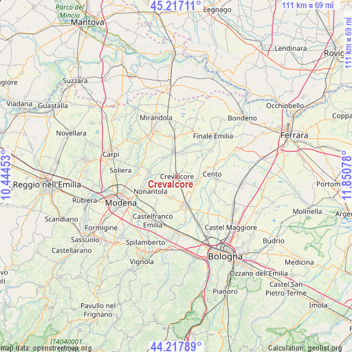
Crevalcore GPS coordinates[2]
44° 43' 10.776" North, 11° 8' 51.54" East
| Map corner | latitude | longitude |
|---|---|---|
| Upper-left | 45.21711°, | 10.44453° |
| Center: | 44.71966°, | 11.14765° |
| Lower-right: | 44.21789°, | 11.85078° |
| Map W x H: | 111.1×111.1 km | = 69×69mi |
| max Lat: | 47.04031° ⇑45.4% North |
| Crevalcore: | 44.71966° |
| min Lat: | ⇓54.6% South 35.50142° |
| min Long | Crevalcore | max Long |
| 6.69888° | 11.14765° | 18.48682° |
| W 44.9%⇐ | ⇒55.1% E |
Elevation
Elevation of Crevalcore is 20 m = 66 ft, and this is 286.7 m = 941 ft below average elevation for this country.
| Max E: |
2085 m = 6841 ft | 89% |
| Avg. | 306.7 m = 1006 ft | |
| Crevalcore | 20 m = 66 ft | |
Min E: |
-4 m = -13 ft | 11% |
See also: Italy elevation on elevation.city.
Geographical zone
Crevalcore is located in North temperate zone (between Tropic of Cancer and the Arctic Circle). Distance of this Northern Tropic circle is 2366.4 km =1470.4 mi to South.| Distance of | km | miles | from Crevalcore |
|---|---|---|---|
| North Pole | 5034.7 | 3128.4 | to North |
| Arctic Circle | 2428.8 | 1509.2 | to North |
| Tropic Cancer | 2366.4 | 1470.4 | to South |
| Equator | 4972.4 | 3089.7 | to South |


Nearby cities:
15 places around Crevalcore: (largest is in red/bold)
• Bomporto
8.9 km =5.5 mi,  280°
280°
• Camposanto
7.9 km =4.9 mi,  355°
355°
• Cento
11.1 km =6.9 mi,  83°
83°
• Decima
6.6 km =4.1 mi,  98°
98°
• Gorghetto
8.2 km =5.1 mi,  313°
313°
• La Grande
6.7 km =4.2 mi,  268°
268°
• Nonantola
9.8 km =6.1 mi,  241°
241°
• Palata Pepoli
10.5 km =6.5 mi,  39°
39°
• Ravarino
4.1 km =2.5 mi, 277°
• San Giovanni in Persiceto
9.5 km =5.9 mi,  162°
162°
• San Pietro
10 km =6.2 mi, 305°
• Sant'Agata Bolognese
6.7 km =4.2 mi,  189°
189°
• Solara
7.2 km =4.5 mi,  323°
323°
• Sorbara
11.5 km =7.1 mi,  285°
285°
• Via Larga
8.1 km =5 mi,  229°
229°
Sources, notices
• [Note1] Compared only with cities in Italy existing in our database
• [Src1] Map data: © OpenStreetMap contributors (CC-BY-SA)
• [Src2] Other city data from geonames.org with taken over terms of usage.
• [Src3] Geographical zone / Annual Mean Temperature by Robert A. Rohde @ Wikipedia
