Milzano geodata
Milzano (Lombardy) is a seat of a third-order administrative division; located in Italy in Europe/Rome (GMT+2) time zone. With population of 1,748 people, there are 4576 cities with bigger population in this country. Compared to other cities in Italy, 66.8% of cities are located further ↓South; 66% of cities are located further →East and 81.2% of cities have higher elevation than Milzano. Note1


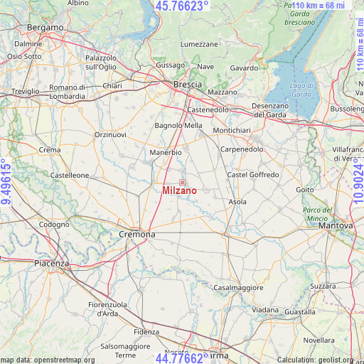
Milzano GPS coordinates[2]
45° 16' 24.888" North, 10° 11' 57.372" East
| Map corner | latitude | longitude |
|---|---|---|
| Upper-left | 45.76623°, | 9.49615° |
| Center: | 45.27358°, | 10.19927° |
| Lower-right: | 44.77662°, | 10.9024° |
| Map W x H: | 110×110 km | = 68.4×68.4mi |
| max Lat: | 47.04031° ⇑33.2% North |
| Milzano: | 45.27358° |
| min Lat: | ⇓66.8% South 35.50142° |
| min Long | Milzano | max Long |
| 6.69888° | 10.19927° | 18.48682° |
| W 34%⇐ | ⇒66% E |
Elevation
Elevation of Milzano is 45 m = 148 ft, and this is 261.7 m = 859 ft below average elevation for this country.
| Max E: |
2085 m = 6841 ft | 81.2% |
| Avg. | 306.7 m = 1006 ft | |
| Milzano | 45 m = 148 ft | |
Min E: |
-4 m = -13 ft | 18.8% |
See also: Italy elevation on elevation.city.
Geographical zone
Milzano is located in North temperate zone (between Tropic of Cancer and the Arctic Circle). Distance of this North polar circle is 2367.2 km =1470.9 mi to North.| Distance of | km | miles | from Milzano |
|---|---|---|---|
| North Pole | 4973.1 | 3090.1 | to North |
| Arctic Circle | 2367.2 | 1470.9 | to North |
| Tropic Cancer | 2428 | 1508.7 | to South |
| Equator | 5034 | 3128 | to South |


Nearby cities:
15 places around Milzano: (largest is in red/bold)
• Alfianello
4.1 km =2.5 mi,  259°
259°
• Bassano Bresciano
8.2 km =5.1 mi,  317°
317°
• Castelletto
7 km =4.3 mi,  22°
22°
• Cigole
3.9 km =2.4 mi,  348°
348°
• Gabbioneta
6.6 km =4.1 mi,  165°
165°
• Gambara
7.8 km =4.8 mi,  106°
106°
• Gottolengo
5.8 km =3.6 mi,  68°
68°
• Ostiano
7.1 km =4.4 mi,  142°
142°
• Pavone del Mella
3.2 km =2 mi,  14°
14°
• Pescarolo
8.9 km =5.5 mi,  186°
186°
• Pontevico
8.4 km =5.2 mi,  269°
269°
• Pralboino
1.7 km =1.1 mi,  115°
115°
• San Gervasio Bresciano
5.6 km =3.5 mi,  312°
312°
• Scandolara Ripa d'Oglio
6.6 km =4.1 mi,  209°
209°
• Seniga
3.6 km =2.2 mi, 207°
Sources, notices
• [Note1] Compared only with cities in Italy existing in our database
• [Src1] Map data: © OpenStreetMap contributors (CC-BY-SA)
• [Src2] Other city data from geonames.org with taken over terms of usage.
• [Src3] Geographical zone / Annual Mean Temperature by Robert A. Rohde @ Wikipedia
