Chialamberto geodata
Chialamberto (Piedmont) is a seat of a third-order administrative division; located in Italy in Europe/Rome (GMT+2) time zone. With population of 200 people, there are 11136 cities with bigger population in this country. Compared to other cities in Italy, 69.2% of cities are located further ↓South; 98.7% of cities are located further →East and 94.6% of cities have lower elevation than Chialamberto. Note1


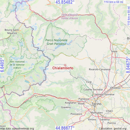
Chialamberto GPS coordinates[2]
45° 21' 46.62" North, 7° 20' 37.068" East
| Map corner | latitude | longitude |
|---|---|---|
| Upper-left | 45.85482°, | 6.6405° |
| Center: | 45.36295°, | 7.34363° |
| Lower-right: | 44.86677°, | 8.04675° |
| Map W x H: | 109.9×109.9 km | = 68.3×68.3mi |
| max Lat: | 47.04031° ⇑30.8% North |
| Chialamberto: | 45.36295° |
| min Lat: | ⇓69.2% South 35.50142° |
| min Long | Chialamberto | max Long |
| 6.69888° | 7.34363° | 18.48682° |
| W 1.3%⇐ | ⇒98.7% E |
Elevation
Elevation of Chialamberto is 858 m = 2815 ft, and this is 551.3 m = 1809 ft above average elevation for this country.
| Max E: |
2085 m = 6841 ft | 5.4% |
| Chialamberto | 858 m 2815 ft | |
| Avg. | 306.7 m = 1006 ft | |
Min E: |
-4 m = -13 ft | 94.6% |
See also: Italy elevation on elevation.city.
Geographical zone
Chialamberto is located in North temperate zone (between Tropic of Cancer and the Arctic Circle). Distance of this North polar circle is 2357.3 km =1464.8 mi to North.| Distance of | km | miles | from Chialamberto |
|---|---|---|---|
| North Pole | 4963.2 | 3084 | to North |
| Arctic Circle | 2357.3 | 1464.8 | to North |
| Tropic Cancer | 2438 | 1514.9 | to South |
| Equator | 5043.9 | 3134.1 | to South |


Nearby cities:
15 places around Chialamberto: (largest is in red/bold)
• Ala di Stura
6.2 km =3.9 mi,  210°
210°
• Balme
11.8 km =7.3 mi,  235°
235°
• Cantoira
4.1 km =2.5 mi,  128°
128°
• Ceres
6.6 km =4.1 mi,  146°
146°
• Ceresole Reale
11.5 km =7.1 mi,  312°
312°
• Coassolo
11.7 km =7.3 mi, 127°
• Coassolo Torinese
11.7 km =7.3 mi, 128°
• Groscavallo
6.7 km =4.2 mi,  274°
274°
• La Villa
12.7 km =7.9 mi, 147°
• Locana
10.5 km =6.5 mi,  57°
57°
• Mezzenile
8.6 km =5.3 mi, 151°
• Monastero di Lanzo
10.1 km =6.3 mi, 132°
• Noasca
10.3 km =6.4 mi,  347°
347°
• Pessinetto
10.2 km =6.3 mi, 146°
• Traves
12.6 km =7.8 mi, 147°
Sources, notices
• [Note1] Compared only with cities in Italy existing in our database
• [Src1] Map data: © OpenStreetMap contributors (CC-BY-SA)
• [Src2] Other city data from geonames.org with taken over terms of usage.
• [Src3] Geographical zone / Annual Mean Temperature by Robert A. Rohde @ Wikipedia
